Town in New South Wales, Australia
| Euabalong West New South Wales | |
|---|---|
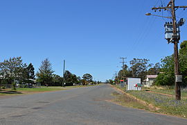
 Uabba Street, the main street of Euabalong West Uabba Street, the main street of Euabalong West | |
 | |
| Coordinates | 33°04′S 146°24′E / 33.067°S 146.400°E / -33.067; 146.400 |
| Population | 66 (2016 census) |
| Established | 1870s |
| Postcode(s) | 2877 |
| LGA(s) | Cobar Shire |
Euabalong West is a small town on the Broken Hill Railway Line that was founded to serve the residents of nearby Euabalong, which was a crossing point for the Lachlan River founded in the 1870s. The town has a population of approximately 70 people, and its main industries are cropping, grazing, and railway-related employment.
Euabalong West railway station opened in 1919 and is served by the weekly Indian Pacific train between Sydney and Perth. NSW TrainLink's weekly Outback Xplorer also serves the town.
The town was the scene of a major freight derailment in January 2007, when a freight train carrying chemicals derailed and spilled wreckage over a 1.5 kilometres (0.93 mi) zone, blocking all rail traffic between Adelaide and Sydney.
Gallery
References
- Australian Bureau of Statistics (27 June 2017). "Euabalong West (State Suburb)". 2016 Census QuickStats. Retrieved 21 March 2018.

- Cobar Shire Council, "Cobar Shire: Villages" Archived 5 February 2007 at the Wayback Machine. Accessed 9 April 2007.
- "Euabalong West railway station". www.nswrail.net. Retrieved 7 April 2008.
- "Western timetable". NSW TrainLink. 7 September 2019.
- Australian Broadcasting Corporation, "Euabalong West derailment cuts track" Archived 3 June 2011 at the Wayback Machine, 15 January 2007. Accessed 9 April 2007.
External links
![]() Media related to Euabalong West at Wikimedia Commons
Media related to Euabalong West at Wikimedia Commons
This Central West geography article is a stub. You can help Misplaced Pages by expanding it. |

