| Site of Special Scientific Interest | |
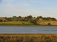
 Ice on the water in winter Ice on the water in winter | |
| Location | Leicestershire Rutland |
|---|---|
| Grid reference | SP 852 955 |
| Interest | Biological |
| Area | 201.3 hectares |
| Notification | 201.3 |
| Location map | Magic Map |
Eyebrook Reservoir (or Eye Brook Reservoir) is a 201.3-hectare (497-acre) reservoir and biological Site of Special Scientific Interest which straddles the border between Leicestershire and Rutland in central England. The closest towns are Corby and Uppingham.
The reservoir was formed by the damming of the Eye Brook. It was built between 1937 and 1940 by Stewarts & Lloyds (supervised by Geoffrey Binnie of Binnie & Partners) to supply water to its Corby steel works. During the Second World War it was used in May 1943 as a practice site for the Dambuster raids, standing in for the Möhne Reservoir; a plaque commemorates this.
The reservoir is an important site for wintering wildfowl, such as wigeon, teal, mallard and pochard. Other habitats are marsh, mudflats, grassland, broad-leaved woodland and plantations. Other species reported from the reservoir include osprey, smew, dunlin and European golden plover. In passage periods scarcer species can be attracted to the reservoir's shores and these regularly include curlew sandpiper, ruff and spotted redshank among the expected waders. Vagrants which have occurred include seabirds such a Leach's petrel and Northern gannet, as well as squacco heron, black-crowned night heron American wigeon, black-winged pratincole, killdeer and a variety of other species, mostly associated with wetlands.
There is no public access to the reservoir, which is reserved for a trout fishery, but it can be viewed from a public footpath which runs along part of the eastern side.
Eyebrook Reservoir is a popular trout fishing venue. The reservoir is regularly stocked with triploid rainbow trout and is home to a native brown trout population. Fly fishing for pike also takes place at the reservoir.
References

- ^ "Designated Sites View: Eye Brook Reservoir". Sites of Special Scientific Interest. Natural England. Retrieved 12 September 2017.
- ^ "Map of Eye Brook Reservoir". Sites of Special Scientific Interest. Natural England. Retrieved 12 September 2017.
- Muir Wood, Sir Alan (1990). Biographical Memoirs of Fellows of the Royal Society: Geoffrey Morse Binnie (13 November 1908 - 5 April 1989). London: Royal Society. pp. 45–57.
- "Eyebrook Reservoir". Domesday Reloaded. BBC. 1986. Retrieved 12 September 2017.
- ^ "Video: Flypast marks 70 years since Dambuster Raids". Harborough Mail. 2013-05-16. Archived from the original on 2013-07-07. Retrieved 3 June 2013.
- Arquati, Richard (16 May 2013). "Air Tattoo to Salute Dambusters". Press releases. Ministry of Defence. Archived from the original on 8 November 2013. Retrieved 3 June 2013.
- "Operation Chastise". Bomber command. Royal Air Force. Retrieved 3 June 2013.
- "Eye Brook Reservoir citation" (PDF). Sites of Special Scientific Interest. Natural England. Retrieved 21 March 2020.
- "Eyebrook Reservoir". NatureSpot. Retrieved 21 March 2020.
- "Eyebrook Reservoir". Leicestershire and Rutland Ornithological Society. Archived from the original on 10 April 2015. Retrieved 21 March 2020.
- "Eyebrook Trout Fishery". Rutland Gillies. Retrieved 12 September 2017.
- Taylor, A.H. (1978) "An analysis of the trout fishing at Eyebrook Reservoir", Journal of Animal Ecology, 47, 407-423.
- ^ "About Us | Fly Fish Eyebrook - Leicestershire Trout Fishery". www.flyfisheyebrook.co.uk. Retrieved 2020-01-16.
External links
- Eyebrook Reservoir, Leicestershire and Rutland Ornithological Society Archived 2015-04-10 at the Wayback Machine
52°33′06″N 0°44′29″W / 52.55167°N 0.74139°W / 52.55167; -0.74139