| Site of Special Scientific Interest | |
 | |
| Location | West Sussex |
|---|---|
| Grid reference | SU 990 095 |
| Interest | Biological |
| Area | 70.2 hectares (173 acres) |
| Notification | 1987 |
| Location map | Magic Map |
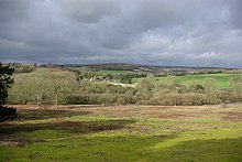
Fairmile Bottom is a 70.2-hectare (173-acre) biological Site of Special Scientific Interest north-west of Arundel in West Sussex. An area of 61.3 hectares (151 acres) is also a Local Nature Reserve.
This is an area of scrub and mature woodland with scattered species-rich chalk grassland. Yew is dominant over much of the woods but in some parts there is a high proportion of beech. According to Natural England there is an "outstanding diversity of beetles" and butterflies include the white admiral and the uncommon silver-washed fritillary.
References
- ^ "Designated Sites View: Fairmile Bottom". Sites of Special Scientific Interest. Natural England. Retrieved 24 April 2019.
- "Map of Fairmile Bottom". Sites of Special Scientific Interest. Natural England. Retrieved 24 April 2019.
- "Designated Sites View: Fairmile Bottom". Local Nature Reserves. Natural England. Retrieved 6 April 2019.
- "Map of Fairmile Bottom". Local Nature Reserves. Natural England. Retrieved 24 April 2019.
- "Fairmile Bottom citation" (PDF). Sites of Special Scientific Interest. Natural England. Retrieved 24 April 2019.
50°52′37″N 0°35′38″W / 50.877°N 0.594°W / 50.877; -0.594
| Local nature reserves in West Sussex | |
|---|---|
| Adur | |
| Arun | |
| Chichester | |
| Crawley | |
| Horsham | |
| Mid Sussex | |