United States historic place
| Falls of Rough Historic District | |
| U.S. National Register of Historic Places | |
 | |
  | |
| Location | Kentucky Route 110, Falls of Rough, Kentucky |
|---|---|
| Coordinates | 37°35′22″N 86°33′03″W / 37.58944°N 86.55083°W / 37.58944; -86.55083 |
| Area | 50 acres (20 ha) |
| Built | 1830 |
| Architectural style | Late Victorian, Gothic Revival, Arch-beam type bridge |
| NRHP reference No. | 78001305 |
| Added to NRHP | January 31, 1978 |
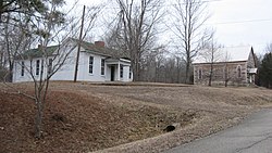
The Falls of Rough Historic District, along Kentucky Route 110 in Falls of Rough, Kentucky, is a 50 acres (20 ha) historic district which was listed on the National Register of Historic Places in 1978. It included 10 contributing buildings, a contributing structure, and three contributing sites.
At its peak during 1900–1930, Falls of Rough was "a small but thriving western Kentucky town of around 250 inhabitants. It consisted of a complex of buildings that included a grist mill (c. 1830), a sawmill, a mill (c. 1890), a general store (c. 1880), a post office (c. 1905), a church (c. 1890) and parsonage, and the Green farm all built by the Green family." The district includes remnants of some of these. Another name proposed for the district was the "Green Family Farm Historic District".
The "visual center" of the district is the brick Willis Green House, built in 1830 and extensively modified in 1879. Its front facade brick is laid in Flemish bond; it rests upon a stone foundation.
The contributing structure in the district is an arch beam iron bridge spanning the Rough River, linking the Breckinridge County and Grayson County sides of the district.
References
- ^ "National Register Information System". National Register of Historic Places. National Park Service. November 2, 2013.
- ^ Gloria Mills; Frederick T. Wilson; Camille Wells (October 1976). "National Register of Historic Places Inventory/Nomination: Falls of Rough Historic District / Green Family Farm Historic District". National Park Service. Retrieved April 12, 2018. With accompanying 24 photos from 1976
| U.S. National Register of Historic Places | |
|---|---|
| Topics | |
| Lists by state |
|
| Lists by insular areas | |
| Lists by associated state | |
| Other areas | |
| Related | |
This article about a property in Grayson County, Kentucky on the National Register of Historic Places is a stub. You can help Misplaced Pages by expanding it. |
- Historic districts on the National Register of Historic Places in Kentucky
- Gothic Revival architecture in Kentucky
- Victorian architecture in Kentucky
- Buildings and structures completed in 1830
- National Register of Historic Places in Breckinridge County, Kentucky
- National Register of Historic Places in Grayson County, Kentucky
- 1830 establishments in Kentucky
- Kentucky Registered Historic Place stubs