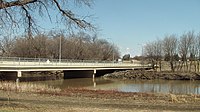
| Fargo-Moorhead Toll Bridge | |
|---|---|
 | |
| Coordinates | 46°53′23″N 96°46′28″W / 46.88972°N 96.77444°W / 46.88972; -96.77444 |
| Carries | 2 lanes of 12th Ave N/15th Ave N and pedestrian path |
| Crosses | Red River |
| Locale | Fargo, North Dakota Moorhead, Minnesota |
| Other name(s) | Fargo-Moorhead Former Toll Bridge |
| Characteristics | |
| Total length | 535' |
| No. of lanes | 2 |
| History | |
| Opened | 1988 |
| Statistics | |
| Daily traffic | 8,800 |
| Location | |
The Fargo-Moorhead Toll Bridge is a former toll bridge on the Red River of the North between Fargo, North Dakota and Moorhead, Minnesota. It connects Moorhead's 15th Avenue N with Fargo's 12th Avenue N.
The bridge was to be privately operated until June 1, 2018, following a five-year extension of its original 25-year charter in 2013. In May 2014, The City of Moorhead sued Bridge Co., the owners of the bridge; and the city of Fargo. Judge Frank Racek ruled in favor of the city of Moorhead and that the ownership of the bridge would be transferred to the two cities.
Prior to the 2014 ownership transfer, the bridge had a toll of $0.75.
Flooding

Due to the frequent flooding of the Red river, the bridge is frequently flooded. The bridge is closed when the water level reaches 28', which occurred most recently in spring of 2023.
See also
References
- "$1.5 Million Grant To Study Replacing Former Toll Bridge in North Fargo/Moorhead". KVRR Local News. 2022-08-09. Retrieved 2023-07-18.
- ^ "Fargo Weighs in on Toll Bridge Debate - Valley News Live - KVLY/KXJB - Fargo/Grand Forks". Archived from the original on 2014-02-22. Retrieved 2014-02-07.
- Alison Voorhees. "KVRR Fox Fargo Moorhead - North Broadway Toll Bridge Closed". Kvrr.com. Retrieved 2017-07-29.
- "Judge's ruling gives northside toll bridge to Fargo, Moorhead". Wday.com. Retrieved 2017-07-29.
- "The City of Fargo - Red River Levels". fargond.gov. Retrieved 2023-07-16.
- "Bridge now closed between Fargo and north Moorhead". InForum. 2023-04-19. Retrieved 2023-07-16.