| Flúðir | |
|---|---|
| Village | |
 Flúðir Flúðir | |
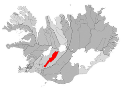
 Location of the Municipality of Hrunamannahreppur Location of the Municipality of Hrunamannahreppur | |
 | |
| Coordinates: 64°13′N 20°33′W / 64.217°N 20.550°W / 64.217; -20.550 | |
| Country | |
| Constituency | South Constituency |
| Region | Southern Region |
| Municipality | Hrunamannahreppur |
| Population | |
| • Total | 818 |
| Time zone | UTC+0 (GMT) |
Flúðir (Icelandic pronunciation: [ˈfluːðɪr̥], anglicised as Fludir) is a village located in the Hrunamannahreppur municipality in the Southern Region, Iceland. It has a population of 818 (as of January 2020). It is not far from Geysir (the first recorded geyser in history) and the Gullfoss waterfall.
Notable sites
- Secret Lagoon (Gamla Laugin) geothermal pool
- Litla-Laxá spring river
- Miðfell hill
- Skalholt cathedral
- Fludir lifting stones at Mountain Villa
- Margrét's doll museum
- Selsvollur golf course
- Fludasveppir mushroom factory
- Folk museum at Grof
- Syðra-Langholt horse rental
- Friðheimar country-style restaurant
References
- ^ "FLÚÐIR". Visit South Iceland. December 5, 2012. Retrieved September 3, 2024.
- ^ "Fludir Travel Guide". www.guidetoiceland.is. May 25, 2016. Retrieved September 3, 2024.
- "Fludir, small town located in the heart of Hrunamannahreppur". Arctic Adventures. December 5, 2012. Retrieved September 3, 2024.
- "Fludir Stones - Images #47 and #48". Mountain Villa, Flúðir, Iceland. June 4, 2023. Retrieved September 2, 2024.
- "Flúðir - The best kept secret of Iceland". Golden Circle Day Tours. June 12, 2023. Retrieved September 2, 2024.
64°07′59″N 20°19′59″W / 64.133°N 20.333°W / 64.133; -20.333
This Iceland location article is a stub. You can help Misplaced Pages by expanding it. |