Census Designated Place in Colorado, United States
| Floyd Hill, Colorado | |
|---|---|
| Census Designated Place | |
 Interstate 70 goes through the community of Floyd Hill. Interstate 70 goes through the community of Floyd Hill. | |
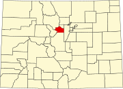
 Location of the Floyd Hill CDP in Clear Creek County, Colorado. Location of the Floyd Hill CDP in Clear Creek County, Colorado. | |
 | |
| Coordinates: 39°43′18″N 105°25′53″W / 39.7216518°N 105.4312576°W / 39.7216518; -105.4312576 (Floyd Hill CDP, Colorado) | |
| Country | |
| State | |
| County | Clear Creek County |
| Government | |
| • Type | unincorporated community |
| Area | |
| • Total | 6.293 sq mi (16.298 km) |
| • Land | 6.290 sq mi (16.290 km) |
| • Water | 0.003 sq mi (0.008 km) |
| Elevation | 8,681 ft (2,646 m) |
| Population | |
| • Total | 1,048 |
| • Density | 170/sq mi (64/km) |
| Time zone | UTC-7 (MST) |
| • Summer (DST) | UTC-6 (MDT) |
| ZIP Code | Evergreen 80439 |
| Area codes | 303 & 720 |
| GNIS feature | Floyd Hill CDP |
Floyd Hill is an unincorporated community and a census-designated place (CDP) located in and governed by Clear Creek County, Colorado, United States. The CDP is a part of the Denver–Aurora–Lakewood, CO Metropolitan Statistical Area. The population of the Floyd Hill CDP was 1,048 at the United States Census 2020. The Evergreen post office (Zip Code 80439) serves the area.
History
Floyd Hill is named after Merril H. Floyd, head of the Clear Creek Wagon Road Company that operated in the 1860s. Mr. Floyd owned a ranch on a hill in the area and the land around the hill, which became known as "Floyd's Hill", where his company built a wagon road over from Idaho Springs to Bergen's ranch.
Geography
The Floyd Hill CDP has an area of 4,027 acres (16.298 km), including 2.0 acres (0.008 km) of water.
Demographics
The United States Census Bureau initially defined the Floyd Hill CDP for the United States Census 2010.
| Year | Pop. | ±% |
|---|---|---|
| 2010 | 998 | — |
| 2020 | 1,048 | +5.0% |
| Source: United States Census Bureau | ||
See also
- Outline of Colorado
- State of Colorado
References
- ^ "State of Colorado Census Designated Places - BAS20 - Data as of January 1, 2020". United States Census Bureau. Retrieved November 4, 2021.
- ^ "U.S. Board on Geographic Names: Domestic Names". United States Geological Survey. Retrieved December 21, 2020.
- "QuickFacts for Colorado". United States Census Bureau. Retrieved October 30, 2021.
- ^ "Zip Code 80439 Map and Profile". zipdatamaps.com. 2020. Retrieved December 21, 2020.
External links
| Municipalities and communities of Clear Creek County, Colorado, United States | ||
|---|---|---|
| County seat: Georgetown | ||
| Cities |  | |
| Towns | ||
| CDPs | ||
| Unincorporated communities | ||
| Ghost towns | ||
| Footnotes | ‡This populated place also has portions in an adjacent county or counties | |