| Fraochaidh | |
|---|---|
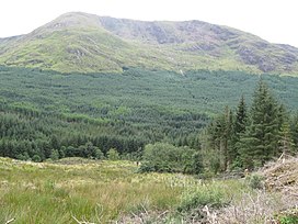
 Fraochaidh, showing its forested lower slopes. Fraochaidh, showing its forested lower slopes. | |
| Highest point | |
| Elevation | 879 m (2,884 ft) |
| Prominence | 551 m (1,808 ft) |
| Listing | Corbett, Marilyn |
| Geography | |
| Location | Highland and Argyll and Bute, Scotland |
| Parent range | Grampian Mountains |
| OS grid | NN029517 |
| Topo map | OS Landranger 41 |
Fraochaidh (879 m) is a mountain in the Grampian Mountains, located between Glen Coe and Oban on the west coast of Scotland. It lies on the border of Highland and Argyll and Bute.
A steep sided mountain, many of its approaches are covered in thick forest plantations. The best route to the summit is from the Glen Coe side to its north.
References
- "Fraochaidh". hill-bagging.co.uk. Retrieved 7 May 2019.
- "walkhighlands Fraochaidh". walkhighlands.co.uk. Retrieved 7 May 2019.
56°36′55″N 5°12′50″W / 56.615398°N 5.213830°W / 56.615398; -5.213830
This Scottish location article is a stub. You can help Misplaced Pages by expanding it. |