Unincorporated community in West Virginia, United States
| Frost, West Virginia | |
|---|---|
| Unincorporated community | |
  | |
| Coordinates: 38°16′14″N 79°52′50″W / 38.27056°N 79.88056°W / 38.27056; -79.88056 | |
| Country | United States |
| State | West Virginia |
| County | Pocahontas |
| Elevation | 2,585 ft (788 m) |
| Time zone | UTC-5 (Eastern (EST)) |
| • Summer (DST) | UTC-4 (EDT) |
| ZIP code | 24940 |
| Area code | 304/681 |
| GNIS feature ID | 1554516 |
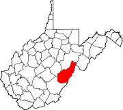
Frost is an unincorporated community in eastern Pocahontas County, West Virginia, United States. Frost is also home to Mountain Quest Institute.
The highly elevated townsite experiences frequent frost conditions, hence the name.
Climate
The climate in this area has mild differences between highs and lows, and there is adequate rainfall year-round. According to the Köppen Climate Classification system, Frost has a marine west coast climate, abbreviated "Cfb" on climate maps.
| Climate data for Frost 3NE, West Virginia, 1991–2020 normals: 2905ft (885m) | |||||||||||||
|---|---|---|---|---|---|---|---|---|---|---|---|---|---|
| Month | Jan | Feb | Mar | Apr | May | Jun | Jul | Aug | Sep | Oct | Nov | Dec | Year |
| Record high °F (°C) | 67 (19) |
71 (22) |
81 (27) |
85 (29) |
88 (31) |
89 (32) |
94 (34) |
93 (34) |
89 (32) |
87 (31) |
79 (26) |
73 (23) |
94 (34) |
| Mean maximum °F (°C) | 58.8 (14.9) |
60.7 (15.9) |
70.7 (21.5) |
79.8 (26.6) |
82.4 (28.0) |
84.9 (29.4) |
86.1 (30.1) |
84.8 (29.3) |
83.9 (28.8) |
78.7 (25.9) |
70.5 (21.4) |
60.9 (16.1) |
87.5 (30.8) |
| Mean daily maximum °F (°C) | 37.4 (3.0) |
41.5 (5.3) |
49.0 (9.4) |
60.8 (16.0) |
69.3 (20.7) |
75.0 (23.9) |
78.4 (25.8) |
78.2 (25.7) |
72.8 (22.7) |
63.3 (17.4) |
51.6 (10.9) |
41.5 (5.3) |
59.9 (15.5) |
| Daily mean °F (°C) | 27.2 (−2.7) |
29.9 (−1.2) |
37.4 (3.0) |
47.4 (8.6) |
56.4 (13.6) |
63.3 (17.4) |
67.1 (19.5) |
66.7 (19.3) |
60.7 (15.9) |
50.3 (10.2) |
39.6 (4.2) |
31.4 (−0.3) |
48.1 (9.0) |
| Mean daily minimum °F (°C) | 17.0 (−8.3) |
18.4 (−7.6) |
25.8 (−3.4) |
34.0 (1.1) |
43.6 (6.4) |
51.7 (10.9) |
55.8 (13.2) |
55.1 (12.8) |
48.5 (9.2) |
37.2 (2.9) |
27.6 (−2.4) |
21.3 (−5.9) |
36.3 (2.4) |
| Mean minimum °F (°C) | −4.2 (−20.1) |
−1.2 (−18.4) |
8.4 (−13.1) |
20.5 (−6.4) |
28.0 (−2.2) |
40.2 (4.6) |
46.1 (7.8) |
45.6 (7.6) |
35.1 (1.7) |
24.0 (−4.4) |
13.4 (−10.3) |
4.6 (−15.2) |
−5.4 (−20.8) |
| Record low °F (°C) | −12 (−24) |
−12 (−24) |
−7 (−22) |
14 (−10) |
23 (−5) |
33 (1) |
41 (5) |
40 (4) |
29 (−2) |
17 (−8) |
4 (−16) |
−3 (−19) |
−12 (−24) |
| Average precipitation inches (mm) | 3.50 (89) |
3.04 (77) |
4.50 (114) |
4.20 (107) |
5.25 (133) |
5.07 (129) |
4.41 (112) |
3.59 (91) |
3.95 (100) |
3.11 (79) |
3.20 (81) |
3.97 (101) |
47.79 (1,213) |
| Average snowfall inches (cm) | 11.60 (29.5) |
14.30 (36.3) |
10.00 (25.4) |
1.60 (4.1) |
0.00 (0.00) |
0.00 (0.00) |
0.00 (0.00) |
0.00 (0.00) |
0.00 (0.00) |
0.40 (1.0) |
2.90 (7.4) |
10.30 (26.2) |
51.1 (129.9) |
| Source 1: NOAA | |||||||||||||
| Source 2: XMACIS (temp records & monthly max/mins) | |||||||||||||
References
- "Frost". Geographic Names Information System. United States Geological Survey, United States Department of the Interior.
- Kenny, Hamill (1945). West Virginia Place Names: Their Origin and Meaning, Including the Nomenclature of the Streams and Mountains. Piedmont, WV: The Place Name Press. p. 256.
- Climate Summary for Frost, West Virginia
- "Frost 3NE, West Virginia 1991-2020 Monthly Normals". Retrieved December 18, 2023.
- "xmACIS". National Oceanic and Atmospheric Administration. Retrieved December 18, 2023.
| Municipalities and communities of Pocahontas County, West Virginia, United States | ||
|---|---|---|
| County seat: Marlinton | ||
| Towns |  | |
| CDPs | ||
| Unincorporated communities |
| |
| Ghost towns | ||
This article about a location in Pocahontas County, West Virginia is a stub. You can help Misplaced Pages by expanding it. |