| Fui Sha Wai Chinese: 灰沙圍 | |
|---|---|
| Village | |
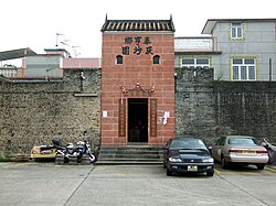
 Entrance gate of Fui Sha Wai Entrance gate of Fui Sha Wai | |
 | |
| Coordinates: 22°28′12″N 114°09′06″E / 22.469915°N 114.151535°E / 22.469915; 114.151535 | |
| Country | People's Republic of China |
| Special administrative region | Hong Kong |
| District | Tai Po District |
| Area | Tai Hang |
| Time zone | UTC+8:00 (HKT) |
Fui Sha Wai (Chinese: 灰沙圍) is a walled village in Tai Hang, Tai Po District, Hong Kong.
Administration


Fui Sha Wai is one of the villages represented within the Tai Po Rural Committee. For electoral purposes, Fui Sha Wai is part of the Lam Tsuen Valley constituency, which was formerly represented by Richard Chan Chun-chit until October 2021.
History
At the time of the 1911 census, the population of Tai Hang Fui Sha Wai was 117. The number of males was 47.
Conservation
The enclosing walls of Fui Sha Wai have been listed as Grade III historic buildings.
See also
- Walled villages of Hong Kong
- Chung Sum Wai (Tai Hang), a nearby walled village in Tai Hang
References
- "Recommended District Council Constituency Areas (Tai Po District)" (PDF). Electoral Affairs Commission. Retrieved 26 November 2021.
- "Tai Po District Council - Tai Po DC Members". District Council. Retrieved 26 November 2021.
- Hase, Patrick (1996). "Traditional Life in the New Territories: The Evidence of the 1911 and 1921 Censuses" (PDF). Journal of the Royal Asiatic Society Hong Kong Branch. 36: 80. ISSN 1991-7295.
- Antiquities Advisory Board. List of the 1,444 Historic Buildings with Assessment Results
External links
- Delineation of area of existing village Tai Hang (Tai Po) for election of resident representative (2019 to 2022) (includes Fui Sha Wai)
- Antiquities Advisory Board. Historic Building Appraisal. Enclosing Walls and Entrance Gate, Fui Sha Wai Pictures of the enclosing walls Pictures of the entrance gate
This Hong Kong location article is a stub. You can help Misplaced Pages by expanding it. |