| Fyrde | |
|---|---|
| Village | |
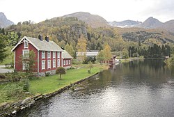
 View of the river which runs through the village View of the river which runs through the village | |
  | |
| Coordinates: 62°03′47″N 6°19′31″E / 62.0631°N 6.3252°E / 62.0631; 6.3252 | |
| Country | Norway |
| Region | Western Norway |
| County | Møre og Romsdal |
| District | Sunnmøre |
| Municipality | Volda Municipality |
| Elevation | 8 m (26 ft) |
| Time zone | UTC+01:00 (CET) |
| • Summer (DST) | UTC+02:00 (CEST) |
| Post Code | 6110 Austefjorden |
Fyrde is a village in Volda Municipality in Møre og Romsdal county, Norway. The village is located at the end of the Austefjorden branch of the main Voldsfjorden. The new European route E39 highway runs past the village of Fyrde. The new 6,563-metre (4.1 mi) long Kviven Tunnel runs through the mountain Kviven connecting the Fyrde area to the village of Grodås in neighboring Hornindal Municipality in Sogn og Fjordane county.
Austefjord Church is located in Fyrde.
References
- "Fyrde, Volda (Møre og Romsdal)". yr.no. Retrieved 2019-09-21.
- Store norske leksikon. "Austefjorden – del av Voldafjorden" (in Norwegian). Retrieved 2013-08-17.
This Møre og Romsdal location article is a stub. You can help Misplaced Pages by expanding it. |