Long-distance walking route in France
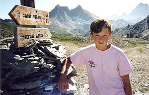
On the GR38 in 1989 The GR 58 , also: Tour du Queyras , is a long-distance walking route of the Grande Randonnée network in France . It forms a 108 km long loop in the Queyras , one of France's regional parks, in the department of the Hautes-Alpes . It passes through Ceillac , Saint-Véran , Abriès , Les Fonds and Brunissard .
References
GR-infos , GR 58
44°40′52″N 6°58′04″E / 44.6812°N 6.9678°E / 44.6812; 6.9678
Categories :
Text is available under the Creative Commons Attribution-ShareAlike License. Additional terms may apply.
**DISCLAIMER** We are not affiliated with Wikipedia, and Cloudflare.
The information presented on this site is for general informational purposes only and does not constitute medical advice.
You should always have a personal consultation with a healthcare professional before making changes to your diet, medication, or exercise routine.
AI helps with the correspondence in our chat.
We participate in an affiliate program. If you buy something through a link, we may earn a commission 💕
↑
