Unincorporated community in Virginia, United States
| Garrisonville | |
|---|---|
| Unincorporated community | |
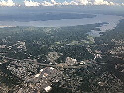
 Aerial view of Garrisonville (foreground) and Aquia Harbour (center) with Aquia Creek and the Potomac River in the background Aerial view of Garrisonville (foreground) and Aquia Harbour (center) with Aquia Creek and the Potomac River in the background | |
   | |
| Coordinates: 38°28′57″N 77°25′36″W / 38.48250°N 77.42667°W / 38.48250; -77.42667 | |
| Country | United States |
| State | Virginia |
| County | Stafford |
| Time zone | UTC−5 (Eastern (EST)) |
| • Summer (DST) | UTC−4 (EDT) |
| ZIP code | 22463 |
| GNIS feature ID | 1499463 |
Garrisonville is an unincorporated community in Stafford County in the U.S. state of Virginia.
Geography
Garrisonville is located at an elevation of 282 ft (86 m), south of Marine Corps Base Quantico.
Transportation

Garrisonville is served by State Route 610 (Garrisonville Road), which passes east—west through the community, and Interstate 95 and U.S. Route 1, which run north—south to the east.
References
- "Garrisonville ZIP Code". zipdatamaps.com. 2022. Retrieved November 30, 2022.
- ^ "Garrisonville". Geographic Names Information System. United States Geological Survey, United States Department of the Interior.
- Dodd, Anita L.; Lee, M. Amanda (2007). Stafford County. Arcadia Publishing. p. ix. ISBN 9780738544106.
| Municipalities and communities of Stafford County, Virginia, United States | ||
|---|---|---|
| County seat: Stafford | ||
| CDPs |  | |
| Unincorporated communities |
| |
| Footnotes | ‡This populated place also has portions in an adjacent county or counties | |
This Stafford County, Virginia state location article is a stub. You can help Misplaced Pages by expanding it. |