Neighbourhood in Vancouver, British Columbia, Canada
| Gastown | |
|---|---|
| Neighbourhood | |
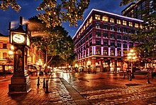
 View of Gastown from Maple Tree Square View of Gastown from Maple Tree Square | |
 | |
| Coordinates: 49°17′05″N 123°06′39″W / 49.284688°N 123.110953°W / 49.284688; -123.110953 | |
| Country | |
| Province | British Columbia |
| City | Vancouver |
| Website | gastown |
Gastown is the original settlement that became the core of the city of Vancouver, British Columbia, Canada, and a national historic site and a neighbourhood in the northwest section of the Downtown Eastside, adjacent to Downtown Vancouver.
Its historical boundaries – the waterfront (now Water Street and the CPR tracks), Carrall Street, Hastings Street, and Cambie Street – followed the borders of the 1870 townsite survey, the proper name and postal address of which was Granville, B.I. ("Burrard Inlet"). The official boundary does not include most of Hastings Street except for the Woodward's and Dominion Buildings, and stretches east past Columbia Street, to the laneway running parallel to the west side of Main Street.
History

| Part of the series on | ||||||||||||||||||||||
| History of Vancouver | ||||||||||||||||||||||
|---|---|---|---|---|---|---|---|---|---|---|---|---|---|---|---|---|---|---|---|---|---|---|
| History | ||||||||||||||||||||||
|
||||||||||||||||||||||
| Events | ||||||||||||||||||||||
|
||||||||||||||||||||||
| Timeline of Vancouver history | ||||||||||||||||||||||
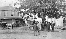
Gastown was Vancouver's first neighbourhood and was named for "Gassy" Jack Deighton, a Yorkshire seaman, steamboat captain and barkeep who arrived in 1867 to open the area's first saloon. He was famous for his habit of talking at length (or "gassing") and the area around his saloon came to be known as "Gassy's town," a nickname that evolved to "Gastown." The town soon prospered as the site of Hastings Mill sawmill, seaport, and quickly became a general centre of trade and commerce on Burrard Inlet as well as a rough-and-rowdy resort for off-work loggers and fishermen as well as the crews and captains of the many sailing ships which came to Gastown or Moodyville, on the north side of the inlet (which was a dry town) to load logs and timber.
In the 1960s, citizens became concerned with preserving Gastown's distinctive and historic architecture, which like the nearby Chinatown and Strathcona was scheduled to be demolished to build a major freeway into the city's downtown. A campaign led by businesspeople and property owners, as well as the counterculture and associated political protestors gained traction to save Gastown. Henk F. Vanderhorst, a Dutch immigrant to Canadian citizen, opened the 'Exposition Gallery', an art gallery on Water Street which started, flourished and encouraged a flow of other fledgling business startups to boom in the Gastown core. His influence with the revitalization of Gastown was acknowledged in 1976 by being awarded 'The First Pioneer Citizen of Gastown' award by Mayor Art Phillips. "A key to the city". Vanderhorst's efforts, in part, pressured the civic, provincial and federal governments to declare Gastown a historical site, protecting its heritage buildings to this day.
Gastown was designated a National Historic Site of Canada in 2009.
21st century

Gastown is a mix of "hip" contemporary fashion and interior furnishing boutiques, tourist-oriented businesses (generally restricted to Water Street), restaurants, nightclubs, poverty and newly upscale housing. In addition, there are law firms, architecture and other professional offices, computer and internet businesses, art galleries, music and art studios, tattoo parlours, and acting and film schools.
In February 2013, The Gastown Gazette began publishing local news and stories about the ongoing protests against gentrification in the Downtown Eastside and Gastown area of Vancouver. The community paper has since gathered provincial and national attention for reports on the neighbourhood.
Gastown has become a hub for technology and new media. It has attracted companies such as Zaui Software, Idea Rebel, MetroQuest, BootUp Labs Entrepreneurial Society, SEOinVancouver and MarketR.
Popular annual events that take place on the cobblestone streets of Gastown include the Vancouver International Jazz Festival and the Global Relay Gastown Grand Prix international bicycle race.

In June 2004, Storyeum opened in Gastown. It was a lively theatrical 65-minute show that re-enacted the history of BC using eight sets that were all located below street level. Unfortunately, due to mounting debt, the attraction closed its doors in October 2006.
The Gassy Jack statue was toppled on February 14, 2022, by protesters during the 31st annual Memorial March for Missing and Murdered Indigenous Women and Girls.
In the summer of 2024, as a pilot project, Water Street was converted into a pedestrian zone with car-free and car-light areas from Richards Street to Carrall Street.
Gastown steam clock
Further information: Steam clock § Gastown steam clock
Gastown's most famous (though nowhere near oldest) landmark is the steam-powered clock on the corner of Cambie and Water Street. It was built in 1977 to cover a steam grate, part of Vancouver's distributed steam heating system, as a way to harness the steam and to prevent street people from sleeping on the spot in cold weather. Its original design was faulty and it had to be powered by electricity after a breakdown. The steam mechanism was completely restored with the financial support of local businesses as it had become a major tourist attraction, and is promoted as a heritage feature although it is of modern invention.
The steam used is low pressure downtown-wide steam heating network (from a plant adjacent to the Georgia Viaduct) that powers a miniature steam engine in its base, in turn driving a chain lift. The chain lift moves steel balls upward, where they are unloaded and roll to a descending chain. The weight of the balls on the descending chain drives a conventional pendulum clock escapement, geared to the hands on the four faces. The steam also powers the clock's sound production, with whistles being used instead of bells to produce the Westminster "chime" and to signal the time.
In October 2014, the clock was temporarily removed for major repairs by its original builder, and was reinstalled January 2015.
References
- "Downtown Eastside Local Area Plan" (PDF). City of Vancouver. 15 March 2014. Retrieved 3 April 2019.
- "Vancouver Neighbourhoods Map". VanMap. City of Vancouver. Retrieved 3 April 2019.
- Lynch, Dana (2019-06-26). "Guide to Gastown in Vancouver, BC". TripSavvy. Retrieved 2022-03-05.
- Kalman, Howard. Exploring Vancouver, University of British Columbia, 1974, page 5
- Bellett, Gerry. "Vancouver's Gastown designated national historic site". The Vancouver Sun. Canwest Publishing Inc. Archived from the original on 2009-07-17. Retrieved 1 January 2015.
- "Pidgin protests in Downtown Eastside concern activist funders". The Globe and Mail. 2013-04-29. Retrieved 2017-09-18.
- "Gastown Tech Cluster".
- Anderson, Sarah (2022-02-14). "Protesters topple Vancouver's Gassy Jack statue in Gastown". DH News. Vancouver: The Daily Hive. Archived from the original on 15 February 2022. Retrieved 2022-02-15.
- "Water Street pedestrian zone pilot". City of Vancouver. City of Vancouver . Retrieved 29 June 2024.
- Robertson, Merv (February 25, 1999). "Administrative Report: RTS MP/ 00474". Former Website of the City of Vancouver. City of Vancouver . Retrieved 1 January 2015.
-
"Gastown Steam Clock undergoes repairs". City of Vancouver. City of Vancouver (B.C., Canada). 2014-10-08. Retrieved 1 January 2015.
The mechanical moving parts of the Steam Clock's device for loading the metal balls have worn over the last 37 years and can no longer be reliably maintained. Mechanical failures have been a common occurrence in the past year, and the proposed repairs to the ball loading device will restore reliability to the Steam Clock while maintaining its historical integrity.
- Baker, Paula (2014-11-19). "Gastown landmark steam clock getting an overhaul". Global News. Shaw Media. Retrieved 1 January 2015.
External links
- Official Gastown Community Website
- Gastown at Virtual Vancouver Archived 2008-02-09 at the Wayback Machine
- Global Relay Gastown Grand Prix
- Club Zone.com "Gastown Bars" page Archived 2008-11-19 at the Wayback Machine
- The Gastown Gazette, community newspaper
- Gastown page, Vancouver Then and Now website, comparisons of old photos with modern locations
Archival photos
- View of Gastown from offshore, 1884, prior to announcement of CPR terminus
- View of Gastown from offshore, 1886
- View of Alexander Street, Gastown c.1911
- View of Water Street from jct. Cordova Street, c.1890
- View of Water Street from Maple Tree Square, 1887 (Sunnyside Hotel at right)
- View of Cordova Street from above intersection of Carrall; July 1, 1890 Dominion Day celebrations
- View of Cordova Street from above intersection of Cambie; c.1900 when this was still the city's principal shopping district
| Neighbourhoods in Vancouver, British Columbia | |||||
|---|---|---|---|---|---|
| Downtown peninsula |
| ||||
| West Side |
| ||||
| East Side |
| ||||
| Other locations | |||||
| Italics indicate neighbourhoods now defunct. | |||||
| National Historic Sites of Canada by location | |
|---|---|
| Provinces | |
| Territories | |
| Other countries | |
