| God's Bridge | |
|---|---|
 The Pennine Way crossing the River Greta at God's Bridge The Pennine Way crossing the River Greta at God's Bridge | |
 | |
| Location | MAGiC MaP |
| Nearest town | Barnard Castle |
| Coordinates | 54°30′33″N 2°4′2″W / 54.50917°N 2.06722°W / 54.50917; -2.06722 |
| Area | 9.3 ha (23 acres) |
| Established | 1986 |
| Governing body | Natural England |
| Website | God's Bridge SSSI |
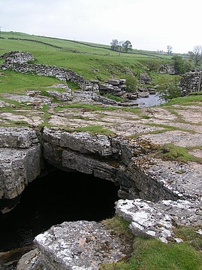
God's Bridge is a Site of Special Scientific Interest in the County Durham district of south-west County Durham, England. It is a natural limestone bridge over the River Greta, just over 3 km upstream from the village of Bowes.
The bridge was formed by a process of cave development in the limestone beneath the river bed and is the best example in Britain of a natural bridge formed in this way. The SSSI covers a portion of the river above and below the bridge where shallow cave development by solutional activity is still taking place.
The Pennine Way crosses the River Greta at God's Bridge.
Yorkshire Dales

A similar formation on the River Doe near Chapel-le-Dale in the Yorkshire Dales has the same name.
References
- "God's Bridge SSSI : Reasons for designating the SSSI status" (PDF). Natural England. Retrieved 1 March 2022.
- OL2 Yorkshire Dales Southern and western areas (Map). 1:25000. Explorer. Ordnance Survey. Retrieved 3 May 2013.