| Native name: Maore, Mahori | |
|---|---|
 Grande-Terre administrative Grande-Terre administrative | |
 | |
| Geography | |
| Location | Indian Ocean and Mozambique Channel |
| Coordinates | 12°49′55″S 45°08′58″E / 12.831887°S 45.149474°E / -12.831887; 45.149474 |
| Area | 368 km (142 sq mi) |
| Area rank | ~11th |
| Highest elevation | 660 m (2170 ft) |
| Highest point | Mount Benara |
| Administration | |
| France | |
| Largest settlement | Mamoudzou (pop. 53,022 (2009) 186,452) |
| Demographics | |
| Population | (2010) |
| Pop. density | 499/km (1292/sq mi) |
| Ethnic groups | Shimaore, Bushi, Arabs, Swahilis, French |
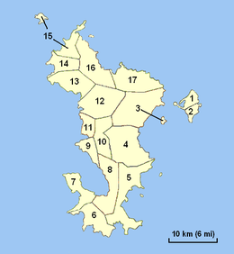
Grande-Terre (French pronunciation: [ɡʁɑ̃d tɛʁ]; Maore or Nyambo Bole in Shimaore) is the main island of the French overseas region of Mayotte. The island is located in the northern Mozambique Channel in the Indian Ocean, namely between northwestern Madagascar and northeastern Mozambique.
History
| This section needs expansion. You can help by adding to it. (October 2022) |
References
- "INSEE Infos No 32" (PDF). INSEE (in French). Government of France. Retrieved 2007-12-02.
- "Mayotte devient le 101e département français", Portail du Gouvernement, 4 April 2011, archived from the original on 25 July 2011,
C'est pourquoi Mayotte devient le 101e département français et le 5e département d'Outre-Mer et région d'Outre-Mer.
This Mayotte location article is a stub. You can help Misplaced Pages by expanding it. |

