| Grzegórzki | |
|---|---|
| Dzielnica of Kraków | |
 Rondo Mogilskie - main transport hub of the district Rondo Mogilskie - main transport hub of the district | |
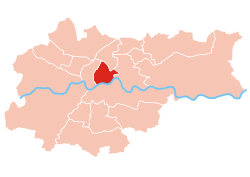
 Location of Grzegórzki within Kraków Location of Grzegórzki within Kraków | |
| Coordinates: 50°3′23.8″N 19°57′11.8″E / 50.056611°N 19.953278°E / 50.056611; 19.953278 | |
| Country | |
| Voivodeship | Lesser Poland |
| County/City | Kraków |
| Government | |
| • President | Małgorzata Ciemięga |
| Area | |
| • Total | 5.85 km (2.26 sq mi) |
| Population | |
| • Total | 28,960 |
| • Density | 5,000/km (13,000/sq mi) |
| Time zone | UTC+1 (CET) |
| • Summer (DST) | UTC+2 (CEST) |
| Area code | +48 12 |
| Website | http://www.dzielnica2.krakow.pl |
Grzegórzki is one of 18 districts of Kraków, located in the central part of the city. The name Grzegórzki comes from a village of same name that is now a part of the district.
According to the Central Statistical Office data, the district's area is 5.85 square kilometres (2.26 square miles) and 28 960 people inhabit Grzegórzki.
History
The oldest part of the district is Wesoła, stretching along Lubicz and Kopernika Streets, which originated as a suburb around St Nicolas' Church on today's Kopernika Street. Situated next to it, Grzegórzki is a former village, incorporated into Krakow in 1910. At the end of the 19th and beginning of the 20th century it was heavily industrialised. A strike in 1936 at the Semperit factory was bloodily suppressed, resulting in 8 deaths. In the northern part of the district, mainly along Beliny-Prażmowskiego and Brodowicza streets, the Officers' housing estate was built from 1925. From the end of the 20th century, the district gradually lost its industrial character and was transformed into an office and residential area. Some of the former factories have been revitalised and transformed into multi-functional complexes, such as Browar Lubicz, Fabryczna City complex and Galeria Kazimierz
Population

Subdivisions of Grzegórzki

Grzegórzki is divided into smaller subdivisions (osiedla). Here's a list of them.
- Dąbie
- Olsza
- Wesoła
- Grzegórzki
- Osiedle Oficerskie
Landmarks
- Church of the Immaculate Conception - former Carmelite church, built 1634-1683 in Baroque style
- Botanic Garden of the Jagiellonian University - founded in 1783
- Kraków University of Economics - designed by Tadeusz Stryjeński and Władysław Ekielski and built 1891-1893 in Renaissance Revival style
- Basilica of the Sacred Heart of Jesus - designed by Franciszek Mączyński, built 1907–1921 in Art Nouveau style with historical motifs
- Krakow Market Hall - built 1937-1940 in modernist style
- K1 Building - skyscraper built 1972-1998 in Postmodern style
- Unity Tower - skyscraper built 1975-2019 in Postmodern style
- Kraków Opera - designed by Romuald Loegler and built 2004-2008 in Postmodern style
- Galeria Kazimierz - shopping mall built 2004-2005 on the site of the former city slaughterhouse with some of its buildings incorporated into the complex
- Lubicz Brewery - former brewery converted into a multifunctional complex
- Fabryczna City - former distillery converted into a multifunctional complex
- Monument to the Armed Deed of the Krakow Proletariat - commemorating the bloodily suppressed strike at the ‘Semperit’ factory in 1936
Gallery
-
 Church of the Immaculate Conception
-
 Kraków University of Economics
-
 Basilica of the Sacred Heart of Jesus
-
 Kraków Market Hall
-
 Kraków Opera
-
 K1 Building
-
 Unity Tower
-
Former city slaughterhouse, now Galeria Kazimierz
-
 Lubicz Brewery
-
 Fabryczna City complex in a former destillery
References
- "Information about Grzegórzki district". Biuletyn Informacji Publicznej. Archived from the original on 10 June 2019. Retrieved 30 August 2017.
- ^ "O Dzielnicy Grzegórzki - Grzegórzki Dzielnica 2 Krakowa". www.dzielnica2.krakow.pl. Retrieved 2024-11-24.
- "23 marca 1936. Rozruchy robotnicze w Krakowie - 8 osób zabitych". historia.interia.pl (in Polish). Retrieved 2024-11-24.
External links
- Official website of Grzegórzki
- Biuletyn Informacji Publicznej Archived 2019-06-10 at the Wayback Machine
| Districts of Kraków | ||
|---|---|---|
| ||
This Poland location article is a stub. You can help Misplaced Pages by expanding it. |