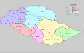
Gupis Tehsil is an administrative division (a tehsil) of Gupis-Yasin District, in Gilgit-Baltistan, a northern region of Pakistan. Gupis Tehsil lies in the southern part of the district. There are many villages and lush green and very pleasant places and resort and historical places like Yangal, Sumal, Hakis, Jindrote, Dahimal, Pingal and Khasunder.
Phander
This area Of Gupis-Yasin District is located in Shandur Pass which joins Chitral and Gilgit Baltistan. It also can be a path to join Tajikistan and Pakistan.
Phander Valley is well known for trout fish found in abundance. Phander includes Shamaran, Chachi, Dalimal, Gulagmuli, and Teru villages.
This area has a lake which abounds in trout. It is about 170 km from Gilgit city and the time required to get there is about 5 hours.
Shandur Pass
This is a 12,500 feet high pass which connects Gilgit to Chitral. The pass remains snow-bound during winters. It is 250 km and 15 hours away by jeep.
Administration
The Gupis tehsil is administratively divided into many Union Councils.
References
- "Khalti Lake, Gupis | Gilgit Baltistan - promoting culture and tourism". gilgit-baltistan.com. Archived from the original on 2020-07-02. Retrieved 2016-01-25.
- "Explore Gupis, Gilgit Baltistan | Destination Pakistan". destinationpak.com. Retrieved 2016-01-25.
- "Avalanche Hit Village, Gupis Tehsil of Ghizar". Dardistan Times. 30 April 2009. Retrieved 2016-01-25.
This Gilgit-Baltistan location article is a stub. You can help Misplaced Pages by expanding it. |