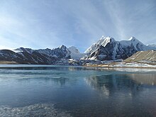
| Gurudongmar Lake | |
|---|---|
 Buddhist Holy Lake -Gurudongmar Lake Buddhist Holy Lake -Gurudongmar Lake | |
  | |
| Location | Mangan District, Sikkim, India |
| Coordinates | 28°01′N 88°43′E / 28.02°N 88.71°E / 28.02; 88.71 |
| Basin countries | Sikkim, India |
| Max. length | Gurudongmar Lakeʍ |
| Surface area | 118 hectares (290 acres) |
| Shore length | 5.34 kilometres (3.32 mi) |
| Surface elevation | 16,909 ft (5,154 m) |
| Settlements | Mangan, North Sikkim 122 km. Lachen, North Sikkim 67 km. |
| Shore length is not a well-defined measure. | |
Gurudongmar Lake is one of the highest lakes in the world and in India, at an elevation of 5,430 m (17,800 ft) according to the Government of Sikkim. It is located in the Great Himalayas in the Mangan District in Indian state of Sikkim, and considered sacred by Buddhists and Sikhs. The lake is named after Guru Padmasambhava—also known as Guru Rinpoche—founder of Tibetan Buddhism, who visited in the 8th century.
Geography

The high altitude lake is located 190 kilometres (120 mi) away from Gangtok, the capital city of Sikkim, and about 5 kilometres (3.1 mi) south of the Tibetan (Chinese) border, in the district of North Sikkim. The lake can be reached by road from Lachen via Thangu Valley. The road from Thangu to Gurudongmar passes through rugged terrain with moraine, which has high alpine pastures covered with many rhododendron trees. While Indian tourists are allowed to visit the lake, foreigners need to get a special permit from the Ministry of Home Affairs in New Delhi.
Features
The lake is fed by the Gurudongmar glacier and is a moraine-dammed lake. It is located to the north of the Kanchendzonga range, in a high plateau area connected with the Tibetan Plateau. It provides one of the source streams which joins the Tso Lahmu and then form the source of the Teesta River. The lake remains completely frozen in the winter months, from November to Mid-May.
The lake has an area of 118 hectares (290 acres) and its peripheral length is 5.34 kilometres (3.32 mi). However, the size of the lake appears small at the place where the devotees offer worship because the larger part of the lake is not visible due to hilly topography obstructing the view. The area surrounding the lake, also known as Gurudongmar, is inhabited by yaks, blue sheep and other wildlife of high altitude.
The lake is fresh water and used to be very clear; the bed of the lake could even be seen from the middle of the lake. Pollution has muddied the waters in recent years, and the lake has taken on a white tinge and has obscured visibility.
In folklore

In Buddhism
Guru Padmasambhava, on his way back from Tibet, visited the holy Dorje Nyima lake, which remained frozen for most of the year. The locals called upon him to help them. After touching a small section of the lake, it never froze again, solving the water problem for the people. The lake became holy and an important place for Buddhist pilgrimage, ensuring the lake's continued existence.
In Sikhism
The Sikhs believed Guru Nanak visited and blessed the lake, leading to the construction of a Gurudwara in 1997-1987, which clashed with local Buddhists.
Dispute

A dispute arose when on the bank of the lake an Indian Army regiment of Sikhs—located at the border with China—considering the lake as the place visited by their saint Guru Nanak, constructed a Gurudwara in 1997–1998. This created anger among the Sikkimese people of the area, who considered the Gurudwara an illegal construction, because their ancient sacred lake had been sanctified by the visit of their Guru Padmasambhava. The government of Sikkim then constituted a high level committee to examine the issue and submit a report. Documents furnished to the committee by the Namgyal Institute of Tibetology, Gangtok, agreed with the claim of the local people that it was without a doubt a Buddhist religious place. This was accepted by the committee. The building constructed by the Sikh regiment was then handed over by the Army to the Lachen Monastery on 6 July 2001, in the presence of the Sub Divisional Magistrate, Chungthang, North Sikkim. The monastery placed a lama as a watchman at the lake, entrusted with the task of maintaining it.
Images
 Panoramic view of Gurudongmar Lake, North Sikkim, India.


See also
Notes
- Terrain maps indicate an elevation under 5,150 metres (16,900 ft).
References
- ^ "Gurudongmar Lake (North Sikkim Tourist Places)". District North Sikkim, Government of Sikkim.
- ^ "Gurudongmar Lake". Official website of Sikkim Tourism, Government of Sikkim.
- Gurudongmar, OpenStreetMap, retrieved 18 November 2021.
- ^ Panigrahy, S; Patel, J G; Parihar, J S (September 2012). "National Wetland Atlas: High Altitude Lakes Of India" (PDF). Gurudongmar Lake. Space Applications Centre, ISRO, Government of India. p. 83. Archived from the original (PDF) on 18 November 2017. Retrieved 15 August 2015.
- Vanessa Betts; Victoria McCulloch (10 February 2014). Indian Himalaya Footprint Handbook: Includes Corbett National Park, Darjeeling, Leh, Sikkim. Footprint Travel Guides. p. 352. ISBN 978-1-907263-88-0.
- Bhuiyan, Chandrashekhar; Flügel, Wolfgang-Albert; Jain, Sharad Kumar (2021). Water Security and Sustainability: Proceedings of Down To Earth 2019. Springer Nature. p. 53. ISBN 9789811598050.
- Husain, Majid (2012). Understanding Geographical Map Entries. Tata McGraw-Hill Education. pp. 282–. ISBN 978-1-259-00090-4.
- ^ Rongmei, Precious. "Did you know of this legend about Sikkim's Gurudongmar Lake?". The Times of India. ISSN 0971-8257. Retrieved 27 November 2023.
- ^ "সিকিমের গুরুদোংমার হ্রদের কিংবদন্তি সম্পর্কে জানেন কি?". Eisamay (in Bengali). Retrieved 27 November 2023.
- Mohinder Singh (1 January 2001). Punjab 2000: Political and Socio-economic Developments. Anamika Publishers & Distributors. pp. 25–. ISBN 978-81-86565-90-2.
External links
| Hydrography of Sikkim | |
|---|---|
| Rivers | |
| Lakes | |
| Glaciers | |