| Hästholmen | |
|---|---|
   | |
| Coordinates: 59°22′14.0″N 18°25′58.6″E / 59.370556°N 18.432944°E / 59.370556; 18.432944 | |
| Country | Sweden |
| Province | Uppland |
| County | Stockholm County |
| Municipality | Vaxholm Municipality |
| Time zone | UTC+1 (CET) |
| • Summer (DST) | UTC+2 (CEST) |
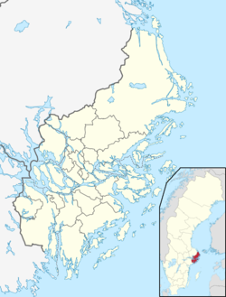
Hästholmen is an island in the Stockholm archipelago in Sweden. Skogsön island lies to its north-west, Tynningö island to its south-west, and the Oxdjupet strait [sv] to its east. Administratively, it is in Vaxholm Municipality and Stockholm County.
Hästholmen has no road connection to the mainland or other islands. It is served from spring to autumn by passenger ships of the Waxholmsbolaget, providing a connection to Vaxholm town and Stockholm city, but there is no service in winter.
This island should not be mistaken for the double-island of Stegesund-Hästholmen, also in Vaxholm Municipality, but situated some 8 kilometres (5.0 mi) to the north-west.
Gallery
-
 Hästholmen seen from the east
-
 The Ginger House on Hästholmen
-
 Cruise ship in the Oxdjupet strait, with Hästholmen to right
References
- ^ "Interactive map - Hästholmen". hitta.se. Archived from the original on 16 June 2023. Retrieved 16 June 2023.
- "Ferry Network Map" (PDF). Archived (PDF) from the original on 31 May 2023. Retrieved 31 May 2023.
- "Hästholmen". Archived from the original on 16 June 2023. Retrieved 16 June 2023.
| Localities in Vaxholm Municipality, Stockholm County, Sweden | |
|---|---|
| Urban areas | |
| Islands | |
| Other places | |
This article about a location in Stockholm County, Sweden is a stub. You can help Misplaced Pages by expanding it. |