| Hammond's Knoll | |
|---|---|
| Shoal | |
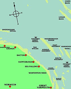
 Location map of Hammond's Knoll (right edge of map) Location map of Hammond's Knoll (right edge of map) | |
| Coordinates: 52°52′N 1°55′E / 52.867°N 1.917°E / 52.867; 1.917 | |
| Location | Southern North Sea |
Hammond's Knoll is a 6-mile (9.7 km) long sandbank off the coast of Norfolk, England at Happisburgh, to the east of Haisborough Sands. The sandbank at low tide has a depth of 6 fathoms (11 m) at each end, and 3 fathoms (5.5 m) in the centre. The sandbank has lighted buoys at its north and east ends. Hammond's Knoll forms part of the Haisborough, Hammond and Winterton Special Area of Conservation.
Ships wrecked on Hammond's Knoll
Some of the ships wrecked here include:
- HMS Invincible - 1801 with the loss of 400 lives.
- Galatea - 1898
- SS English Trader - 1941
| This list is incomplete; you can help by adding missing items. (August 2008) |
See also
- Haisborough Sands - nearby sandbank, similarly treacherous
- Scroby Sands
References
- Special Area of Conservation (SAC):Haisborough, Hammond and Winterton
- Jolly, Cyril (1988). The Loss of the English Trader. Acorn Editions. ISBN 0-906554-06-3.
This article about a specific oceanic location or ocean current is a stub. You can help Misplaced Pages by expanding it. |
This Norfolk location article is a stub. You can help Misplaced Pages by expanding it. |