| Harbrinkhoek Haarbig (Twents) | |
|---|---|
| Village | |
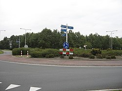
 Roundabout in Harbrinkhoek Roundabout in Harbrinkhoek | |
 The town centre (dark green) and the statistical district (light green) of Harbrinkhoek in the municipality of Tubbergen. The town centre (dark green) and the statistical district (light green) of Harbrinkhoek in the municipality of Tubbergen. | |
  | |
| Coordinates: 52°23′N 6°43′E / 52.383°N 6.717°E / 52.383; 6.717 | |
| Country | Netherlands |
| Province | Overijssel |
| Municipality | Tubbergen |
| Area | |
| • Total | 5.12 km (1.98 sq mi) |
| Elevation | 13 m (43 ft) |
| Population | |
| • Total | 1,880 |
| • Density | 370/km (950/sq mi) |
| Demonym(s) | Harbrinkhoekers, Grupndrieters |
| Time zone | UTC+1 (CET) |
| • Summer (DST) | UTC+2 (CEST) |
| Postal code | 7615 |
| Dialing code | 0546 |
Harbrinkhoek (Tweants: Haarbig) is a village in the Dutch province of Overijssel. It is a part of the municipality of Tubbergen, and lies about 5 km northeast of Almelo.
It was first mentioned in 1844 as Harbrink, and means "settlement of the people of Harbert (person)". In the 1950s, the hamlet turned into a little village. The village is twinned with Mariaparochie, but both still have separate place name signs, statistical entries and postal codes.
References
- ^ "Kerncijfers wijken en buurten 2021". Central Bureau of Statistics. Retrieved 17 March 2022.
- "Postcodetool for 7664NA". Actueel Hoogtebestand Nederland (in Dutch). Het Waterschapshuis. Retrieved 17 March 2022.
- "Harbrinkhoek - (geografische naam)". Etymologiebank (in Dutch). Retrieved 17 March 2022.
- "Harbrinkhoek-Mariaparochie". Plaatsengids (in Dutch). Retrieved 17 March 2022.
| Populated places in the municipality of Tubbergen | |
|---|---|
| Towns | |
| Villages | |
| Hamlets | |
| List of cities, towns and villages in Overijssel | |
This Overijssel location article is a stub. You can help Misplaced Pages by expanding it. |