Township in Indiana, United States
| Harmony Township Posey County | |
|---|---|
| Township | |
 | |
| Coordinates: 38°07′18″N 87°54′24″W / 38.12167°N 87.90667°W / 38.12167; -87.90667 | |
| Country | United States |
| State | Indiana |
| County | Posey |
| Government | |
| • Type | Indiana township |
| Area | |
| • Total | 35.93 sq mi (93.05 km) |
| • Land | 35.24 sq mi (91.28 km) |
| • Water | 0.68 sq mi (1.77 km) |
| Elevation | 407 ft (124 m) |
| Population | |
| • Total | 1,245 |
| • Density | 35/sq mi (13/km) |
| FIPS code | 18-31504 |
| GNIS feature ID | 453374 |
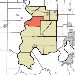
Harmony Township is one of ten townships in Posey County, Indiana. As of the 2020 census, its population was 1,245.
| Census | Pop. | Note | %± |
|---|---|---|---|
| 1890 | 2,304 | — | |
| 1900 | 2,443 | 6.0% | |
| 1910 | 2,168 | −11.3% | |
| 1920 | 1,841 | −15.1% | |
| 1930 | 1,793 | −2.6% | |
| 1940 | 2,151 | 20.0% | |
| 1950 | 2,107 | −2.0% | |
| 1960 | 1,809 | −14.1% | |
| 1970 | 1,618 | −10.6% | |
| 1980 | 1,536 | −5.1% | |
| 1990 | 1,432 | −6.8% | |
| 2000 | 1,473 | 2.9% | |
| 2010 | 1,338 | −9.2% | |
| 2020 | 1,245 | −7.0% | |
| Source: US Decennial Census | |||
History
Harmony Township was organized in 1821. A large share of the first settlers being Harmonites caused the name to be selected.
The James Elliott Farm and New Harmony Historic District are listed on the National Register of Historic Places.
Adjacent townships
- Indiana
- Posey County
- Center Township (Southeast)
- Lynn Township (South)
- Robb Township (Northeast)
- Posey County
- Illinois
- White County
- Hawthorne Township (Southwest)
- Phillips Township (Northwest)
- White County
Cities
Unincorporated places
Education
It is within the Metropolitan School District of North Posey County, which operates North Posey High School.
New Harmony Town and Township Consolidated Schools consolidated into MSD of North Posey County as of 2012.
References
- "US Board on Geographic Names". United States Geological Survey. October 25, 2007. Retrieved January 31, 2008.
- "U.S. Census website". United States Census Bureau. Retrieved January 31, 2008.
- "Explore Census Data". data.census.gov. Retrieved April 9, 2024.
- "Township Census Counts: STATS Indiana".
- Leffel, John C. (1913). History of Posey County, Indiana. Standard Publishing Company. p. 78.
- History of Posey County, Indiana: from the earliest times to the present. Goodspeed Publishing Co. 1886. p. 278.
- "National Register Information System". National Register of Historic Places. National Park Service. July 9, 2010.
- "2020 CENSUS - SCHOOL DISTRICT REFERENCE MAP: Posey County, IN" (PDF). U.S. Census Bureau. Retrieved June 11, 2024. - Text list
- "Decision finalized to merge Hew Harmony and N. Posey". WFIE (14 News). January 21, 2012. Retrieved June 11, 2024.
External links
| Municipalities and communities of Posey County, Indiana, United States | ||
|---|---|---|
| County seat: Mount Vernon | ||
| City | ||
| Towns | ||
| Townships | ||
| CDPs | ||
| Other communities | ||
| Footnotes | ‡This populated place also has portions in an adjacent county or counties | |
This Posey County, Indiana location article is a stub. You can help Misplaced Pages by expanding it. |
