Human settlement in Wales
| Haroldston West | |
|---|---|
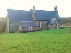
 St Madoc's Church St Madoc's Church | |
 | |
| OS grid reference | SM862147 |
| Community |
|
| Principal area | |
| Country | Wales |
| Sovereign state | United Kingdom |
| Post town | Haverfordwest |
| Postcode district | SA62 |
| Police | Dyfed-Powys |
| Fire | Mid and West Wales |
| Ambulance | Welsh |
| UK Parliament | |
| Senedd Cymru – Welsh Parliament | |
| |
Haroldston West is a rural coastal parish in west Pembrokeshire, Wales, 5.5 miles (8.9 km) west of Haverfordwest. It is in the community of Merlin's Bridge.
History
A number of prehistoric remains exist in the parish.
Haroldston West parish was in the ancient Hundred of Rhos, Pembrokeshire, and in 1833 had a population of 155. Its name is taken from that of an Anglo-Norman who held local lands.
In 1872 the population was 149, living in 28 houses in an area of 1,718 acres (6.95 km).
During the Second World War there was a Relief Landing Ground (RLG) for RAF Withybush called Haroldston airfield which was never used for emergency landings.
Church
The parish church is dedicated to St Madoc of Ferns. Before the 1880s the church was a "barn-like old church of nave and chancel with big sash windows and a makeshift roof of salvaged ships' timbers" but had become derelict. It was rebuilt in 1885.
References
- ^ "GENUKI: Haroldston West". Retrieved 25 April 2015.
- "GENUKI: Parish map". Retrieved 25 April 2015.
- Royal Commission on the Ancient and Historical Monuments of Wales. HMSO. 1925. p. 107. Retrieved 25 April 2015.
- "A Vision of Britain:Haroldston West". Retrieved 25 April 2015.
- RCAHMW. "HAROLDSTONE AIRFIELD". Coflein. Retrieved 25 October 2019.
- "St Madoc of Ferns". Retrieved 25 April 2015.
- Lloyd, Orbach & Scourfield (2004). Pembrokeshire. Yale University Press. p. 200. ISBN 0300101783. Retrieved 25 April 2015.