| Hashikura Prefectural Natural Park | |
|---|---|
| 箸蔵県立自然公園 | |
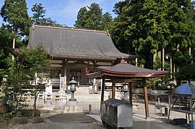
 Unpen-ji Unpen-ji | |
  | |
| Location | Tokushima Prefecture, Japan |
| Coordinates | 34°03′54″N 133°49′30″E / 34.065°N 133.825°E / 34.065; 133.825 |
| Area | 11.83 km |
| Established | 1 January 1967 |
Hashikura Prefectural Natural Park (箸蔵県立自然公園, Hashikura kenritsu shizen kōen) is a Prefectural Natural Park in western Tokushima Prefecture, Japan. Established in 1967, the park spans the borders of the municipalities of Miyoshi and Higashimiyoshi. The park encompasses a stretch of the Yoshino River as well as the temples of Hashikura-ji (箸蔵寺) and Unpen-ji (雲辺寺), temple 66 on the Shikoku pilgrimage.
See also
References
- "徳島県の自然公園" [Natural Parks of Tokushima Prefecture] (in Japanese). Tokushima Prefecture. Archived from the original on 11 April 2013. Retrieved 26 June 2012.
- "徳島県自然公園一覧表" [List of Natural Parks in Tokushima Prefecture] (in Japanese). Tokushima Prefecture. Retrieved 26 June 2012.
This article about a national/quasi-national park or protected area in Japan, or related topic is a stub. You can help Misplaced Pages by expanding it. |