| Hay Creek | |
|---|---|
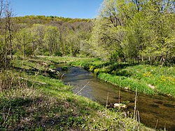
 Hay Creek in May 2021 Hay Creek in May 2021 | |
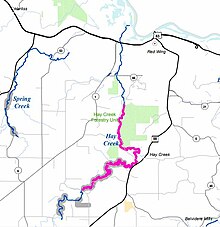
 Hay Creek and nearby Spring Creek Hay Creek and nearby Spring Creek | |
 | |
| Location | |
| Country | United States |
| State | Minnesota |
| County | Goodhue |
| Physical characteristics | |
| Source | |
| • coordinates | 44°24′36″N 92°41′37″W / 44.4099661°N 92.6935281°W / 44.4099661; -92.6935281 |
| Mouth | |
| • location | Red Wing, Minnesota |
| • coordinates | 44°34′25″N 92°33′13″W / 44.5735787°N 92.5535244°W / 44.5735787; -92.5535244 |
| Length | 25.1 mi (40.4 km) |
| Basin features | |
| River system | Upper Mississippi River |
Hay Creek is a small trout stream in southeastern Minnesota. It has its headwaters west of Goodhue and empties into the Mississippi River just to the north of Red Wing. It runs 25.1 miles (40.4 km). Hay Creek was named for the hay meadows near its banks. A railroad once ran along Hay Creek from the claybanks near Goodhue to the pottery and stoneware factories in Red Wing, which also made use of the water from the creek. The railroad was torn up in 1937, but traces such as trestle pilings remain.
Habitat
Historically, Hay Creek was home to Brook trout and other species, which were depopulated due to farming practices in the late 18th and 19th centuries. In the mid-1970s, the Minnesota Department of Natural Resources started focusing on restoring Hay Creek. By 1976, over half of the length of Hay Creek is a Minnesota designated trout stream. Like the Vermillion River, Hay Creek receives extensive fishing pressure due to its proximity to Minneapolis–St. Paul. Minnesota Trout Unlimited has joined the restoration efforts along Hay Creek.
See also
References
- ^ U.S. Geological Survey Geographic Names Information System: Hay Creek
- Red Wing, Minnesota, 7.5 Minute Topographic Quadrangle, USGS, 1974 (1994 rev.)
- U.S. Geological Survey. National Hydrography Dataset high-resolution flowline data. The National Map Archived 2012-03-29 at the Wayback Machine, accessed October 4, 2012
- Upham, Warren (1920). Minnesota Geographic Names: Their Origin and Historic Significance. Minnesota Historical Society. p. 207.
- Chicago Great Western Railway Co. Safety News, June 30, 1968
- "Hay Creek: Restoration Efforts Have Made It A Top-Level Trout Stream". Lake Pepin Legacy Alliance. December 7, 2020. Retrieved March 26, 2021.
- "MN DNR Trout Streams Map 14" (PDF). MN DNR. Retrieved May 21, 2021.
- "Fishing Hay Creek". Minnesota Trout Unlimited. Retrieved March 26, 2021.
- Waters, Thomas F. (1977). Streams and Rivers of Minnesota. Minneapolis: University Of Minnesota Press. pp. 249, 264, 265. ISBN 0816609608.
External links
- "Trout Habitat Improvements on Hay Creek". CFANS UMN. Archived from the original on 2008-09-30.
| Minnesota tributaries of the Upper Mississippi River below St Anthony Falls | |
|---|---|
| Minnesota River | |
| St. Croix River | |
| Cannon River |
|
| Zumbro River |
|
| Whitewater River |
|
| Root River |
|
| Upper Iowa River (Iowa, Minnesota) |
|
| Iowa River (Iowa) | |
| Des Moines River (Iowa, Minnesota, Missouri) |
|
| Missouri River (Missouri, Iowa) |
|
| Other rivers and streams |
|
| Streams by region | |
| See also: List of rivers of Minnesota, North Shore Streams, Wisconsin rivers, Iowa rivers, North Dakota rivers | |