| Hieslum | |
|---|---|
| Village | |
 Hieslum Church Hieslum Church | |
 Flag Flag Coat of arms Coat of arms | |
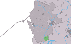
 Location in the former Wûnseradiel municipality Location in the former Wûnseradiel municipality | |
  | |
| Coordinates: 53°0′30″N 5°29′20″E / 53.00833°N 5.48889°E / 53.00833; 5.48889 | |
| Country | |
| Province | |
| Municipality | |
| Area | |
| • Total | 3.16 km (1.22 sq mi) |
| Elevation | 0.1 m (0.3 ft) |
| Population | |
| • Total | 85 |
| • Density | 27/km (70/sq mi) |
| Postal code | 8762 |
| Dialing code | 0515 |
Hieslum is a small village in Súdwest-Fryslân in the province of Friesland, Netherlands. It had a population of around 90 in January 2017.
History
The village was first mentioned between 825 and 842 as Hasalon. The name means "settlement near hazel trees (corylus avellana)". Hieslum is a terp (artificial living hill) which used to be located between lakes. The lakes were later poldered.
The Dutch Reformed church was built in 1874 as a replacement of a church from around 1300. It is almost identical to the church of Idsegahuizum.
Hieslum was home to 64 people in 1840. Before 2011, the village was part of the Wûnseradiel municipality.
References
- ^ "Kerncijfers wijken en buurten 2021". Central Bureau of Statistics. Retrieved 5 April 2022.
two entries
- "Postcodetool for 8762PJ". Actueel Hoogtebestand Nederland (in Dutch). Het Waterschapshuis. Retrieved 5 April 2022.
- Kerncijfers wijken en buurten 2017 - CBS Statline
- "Hieslum - (geografische naam)". Etymologiebank (in Dutch). Retrieved 6 April 2022.
- ^ "Hieslum". Friesland Wonderland (in Dutch). Retrieved 6 April 2022.
- ^ "Hieslum". Plaatsengids (in Dutch). Retrieved 6 April 2022.
External links
![]() Media related to Hieslum at Wikimedia Commons
Media related to Hieslum at Wikimedia Commons
This Friesland location article is a stub. You can help Misplaced Pages by expanding it. |