| Hirschau | |
|---|---|
| Town | |
 Hirschau seen from Monte Kaolino Hirschau seen from Monte Kaolino | |
 Coat of arms Coat of arms | |
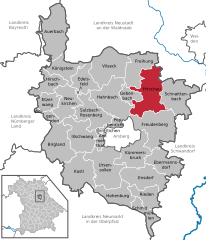
Location of Hirschau within Amberg-Sulzbach district
 | |
  | |
| Coordinates: 49°32′N 11°57′E / 49.533°N 11.950°E / 49.533; 11.950 | |
| Country | Germany |
| State | Bavaria |
| Admin. region | Upper Palatinate |
| District | Amberg-Sulzbach |
| Government | |
| • Mayor (2020–26) | Hermann Falk (CSU) |
| Area | |
| • Total | 74.90 km (28.92 sq mi) |
| Elevation | 411 m (1,348 ft) |
| Population | |
| • Total | 5,666 |
| • Density | 76/km (200/sq mi) |
| Time zone | UTC+01:00 (CET) |
| • Summer (DST) | UTC+02:00 (CEST) |
| Postal codes | 92242 |
| Dialling codes | 09622 |
| Vehicle registration | AS |
| Website | hirschau.de |
Hirschau (German pronunciation: [ˈhɪʁʃaʊ̯] ) is a municipality in the Amberg-Sulzbach district, Upper Palatinate, Bavaria, Germany.
Geography
Hirschau lies directly on the Bundesstraße 14 (Nuremberg - Rozvadov), 13 km northeast of Amberg and about 65 km east of Nuremberg. Apart from the small town Hirschau, the municipality consists of the following villages:

- Burgstall
- Dienhof
- Ebenhof
- Ehenfeld
- Hölzlmühle
- Hummelmühle
- Kindlas
- Krickelsdorf
- Kricklhof
- Krondorf
- Massenricht
- Mittelmühle
- Obersteinbach
- Rödlas
- Sargmühle
- Scharhof
- Schwärzermühle
- Steiningloh
- Träglhof
- Untersteinbach
- Urspring
- Urspringermühle
- Waldmühle
- Weiher
Economy
Kaolin, used for the production of porcelain, has been mined at Hirschau since 1901. Interesting is the Monte Kaolino, a 120 meter high mound made from 32,000,000 tons of quartz sand from excess sand in years of operation. It is now used as a (sand) skiing/camping resort during the summer months. It is also the place where the yearly Sandboarding Championships are held.
Twin towns – sister cities
See also: List of twin towns and sister cities in GermanyHirschau is member of the so called "Kaolinstädtepartnerschaft". It connects cities, which are connected to the mineral Kaolin. The partnership was established in November 2004. Aside Hirschau the members of this partnership are the bavarian cities Tirschenreuth und Schnaittenbach, from Saxony Königswartha, Sornzig-Ablaß and the cities Mügeln and Nová Role from Czech Republic and Nowogrodziec from Poland.
Notable people
- Ferdinand Janner (born 4 February 1836 in Hirschau – 1 November 1895 in Regensburg, Germany) German theologian
References
- Liste der ersten Bürgermeister/Oberbürgermeister in kreisangehörigen Gemeinden, Bayerisches Landesamt für Statistik, 15 July 2021.
- Genesis Online-Datenbank des Bayerischen Landesamtes für Statistik Tabelle 12411-003r Fortschreibung des Bevölkerungsstandes: Gemeinden, Stichtag (Einwohnerzahlen auf Grundlage des Zensus 2011).
- "Hirschau". Retrieved 2024-02-15.
- "Ortsteile mit Postleitzahl". Retrieved 2024-02-15.
- "Partnerschaften" (in German). Archived from the original on 2011-08-02. Retrieved 2024-01-18.
| Towns and municipalities in Amberg-Sulzbach | ||
|---|---|---|
| ||
This Amberg-Sulzbach location article is a stub. You can help Misplaced Pages by expanding it. |
