| Cape D'Aguilar | |||||||||||
|---|---|---|---|---|---|---|---|---|---|---|---|
 Cape D'Aguilar Cape D'Aguilar | |||||||||||
| Traditional Chinese | 鶴咀 | ||||||||||
| Simplified Chinese | 鹤咀 | ||||||||||
| Literal meaning | Crane Beak | ||||||||||
| |||||||||||

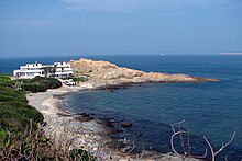
Cape D'Aguilar (Chinese: 鶴咀) is a cape on Hong Kong Island, Hong Kong. The cape is on the southeastern end of D'Aguilar Peninsula. To its north are Shek O and D'Aguilar Peak.
Name
It is named after Major-General George Charles d'Aguilar.
History

The name Cape D'Aguilar appeared first on a map in 1845 surveyed by Lieutenant Collinson and Sir John Francis Davis. (see image) The Chinese name likely originated from the nearby village Hoktsuewan (鶴嘴灣) Around the same time and before, Cape D'Aguilar was also regularly named Tylong Head in maps, a direct translation of the Chinese 大浪頭 .
Geography
Cape D'Aguilar is in the Southern District. Nearby, there are two small islands collectively called Kau Pei Chau (狗髀洲). A channel called Sheung Sze Mun (雙四門) is located close to the cape.
Cape D'Aguilar Road is the only road for access. The Hong Kong Government Gazette confirmed the name on April 12, 1935:
Road branching off Shek O Road at Windy Gap and terminating at Cape D'Aguilar Wireless Station ... Cape D'Aguilar Road 鶴 嘴 道
— No. 302, Hong Kong Government Gazette, 28 September 1935,
Marine Reserve
See also: Cape D'Aguilar Marine ReserveCape D'Aguilar is environmentally protected as part of the Cape D'Aguilar Marine Reserve.
Sightseeings
Common sightseeings for visitors include the Bones of Miss Willy, a whale's skeleton display mounted in front of the University of Hong Kong's Swire Institute of Marine Science.
The Crab's Eye is a sea cave off the Cape D'Aguilar Road, connected to the Thunder Cave. It is also a popular sightseeing point for tourists.
Another popular sightseeing point is the Bokhara Battery, the remains of an artillery battery that is used during the Battle of Hong Kong.
See also
- Cape D'Aguilar Lighthouse
- Green Island Lighthouse Compound
- Waglan Lighthouse
- Tang Lung Chau Lighthouse
References
- https://www.hkmaps.hk/map.html?1845
- https://www.hkmaps.hk/map.html?1844.2
- https://www.hkmaps.hk/map.html?1846
- "District Council Constituency Boundaries - Southern District (Sheet 2)" (PDF). Electoral Affairs Commission. Retrieved 12 April 2021.
- "Hong Kong Government Gazettes 1935" (PDF). Retrieved 5 December 2024.
- Historic building appraisal aab.gov.hk
External links
22°12′28″N 114°15′38″E / 22.20778°N 114.26056°E / 22.20778; 114.26056
| Urban areas of Hong Kong, Kowloon and New Territories | |||||||||||
|---|---|---|---|---|---|---|---|---|---|---|---|
| Hong Kong |
|  | |||||||||
| Kowloon |
| ||||||||||
| New Kowloon |
| ||||||||||
| New Territories |
| ||||||||||
| Official place names are summarized from "Geoinfo Map" of Government of Hong Kong Special Administrative Region, "Hong Kong Guide" of Lands Department, "Hong Kong Guide Book" of Universal Publications Ltd. and "Areas and Districts" of Rating and Valuation Department. M:Narrow meaning of urban areas KL: Kowloon Peninsula at the south of Boundary Street NKL: Former New Territories area at the north of Boundary Street and at the south of Lion Rock 1: Common definition (1) 2: Common definition (2) 3: Common definition (3) 4: Areas not adopting small house concessionary right of indigenous inhabitants 5: Jurisdiction area of former Urban Council 6: Definition of "Metropolitan Area" of Planning Department 7: Jurisdiction area of Urban Renewal Authority 8: Unique operating area of urban taxis 9: "Urban" (9a) and "Extended Urban" (9b) areas defined by Hong Kong Housing Authority 10: Definition of Urban rates 11: Hospital cluster belongs to Hong Kong or Kowloon 12: Police region belongs to Hong Kong or Kowloon 13: Regions having 999-year land lease 14: Geographical Constituency in Hong Kong Legislative Council belongs to Hong Kong or Kowloon 15: Regional Education Office belongs to Hong Kong or Kowloon 16: Primary One Admission School Net belongs to Hong Kong or Kowloon | |||||||||||
This Hong Kong Island location article is a stub. You can help Misplaced Pages by expanding it. |