| Nickname: Magellan's First Landing Site | |
|---|---|
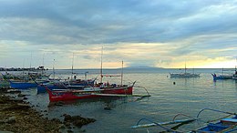
 Homonhon Island, Guiuan, Eastern Samar at sunset (view southwest from Guiuan Integrated Transport Terminal) Homonhon Island, Guiuan, Eastern Samar at sunset (view southwest from Guiuan Integrated Transport Terminal) | |
  | |
| Geography | |
| Coordinates | 10°45′20″N 125°44′21″E / 10.75556°N 125.73917°E / 10.75556; 125.73917 |
| Adjacent to | |
| Area | 105.2 km (40.6 sq mi) |
| Coastline | 57.5 km (35.73 mi) |
| Highest elevation | 1,227 ft (374 m) |
| Highest point | Homonhon Peak |
| Administration | |
| Philippines | |
| Region | Eastern Visayas |
| Province | Eastern Samar |
| Municipality | Guiuan |
| Largest settlement | Casuguran (pop. 1,032) |
| Demographics | |
| Population | 4,722 (2024) |
| Pop. density | 41.9/km (108.5/sq mi) |
Homonhon Island is an island in the province of Eastern Samar, Philippines, on the east side of Leyte Gulf. The 20-kilometre (12 mi) long island is part of the municipality of Guiuan, encompassing eight barangays: Bitaugan, Cagusu-an, Canawayon, Casuguran, Culasi, Habag, Inapulangan, and Pagbabangnan.
Mantoconan, an islet just off the northwest corner of Homonhon, is also part of the approximately 7,500 islands comprising the Philippine Archipelago. The island is one of the early Pacific contact sites between the East and the West.
History
During the first circumnavigation of the globe, Ferdinand Magellan's three surviving vessels passed the Marianas, but did not land, even though he was out of food after crossing the Pacific Ocean. Yet he landed on the island of Homonhon on March 16, 1521. Despite Homonhon being uninhabited at that time, he was detected by the fishing boats of nearby local settlements in Suluan. The local leaders arrived in more boats, receiving him warmly and trading food and supplies with Magellan's crew. Magellan later left for Limasawa Island.
Up to the early Spanish period, Ibabaonon (bygone term for Bisaya of the eastern and northern Samar coast) revered the island as the sacred residence of Makapatag, the male aspect of the supreme diwata Malaon.
Barangays
List of Barangays in Homonhon island by population (2020 census)
| Barangay | Population |
|---|---|
| Bitaugan | 445 |
| Cagusu-an | 707 |
| Canawayon | 427 |
| Casuguran | 964 |
| Culasi | 446 |
| Habag | 317 |
| Inapulagan | 548 |
| Pagbabangnan | 550 |
| Total | 4,413 |
Economy
The island hosts four large-scale mining operations that are involved in extracting nickel and chromite since the 1980s.
References
- ^ "Islands of Philippines". Island Directory. United Nations Environment Programme. Archived from the original on 25 April 2019. Retrieved 3 October 2017.
- W.D. Brownlee (Master Mariner), 1974. The First Ships Around the World ISBN 0-8225-1204-1, p.44.
- Richard Humble, The Voyage of Magellan, Franklin Watts ISBN 0-531-10638-1 p.20.
- Laurence Bergreen, Over the Edge of the World : Magellan's Terrifying Circumnavigation of the Globe HarperCollins Publishers ISBN 0-06-621173-5
- Borrinaga, George Emmanuel (2022). "Wrath of the Diwata: Crises and Bisayan Responses to Jesuit Evangelization in Leyte, Samar, and Bohol from 1595 to 1650". The Journal of History. 68: 135–136 – via Academia.
- "Advocates urge NHCP to save Homonhon Island from mining". Rappler. April 25, 2024. Retrieved April 25, 2024.
This article about a location in Eastern Visayas region is a stub. You can help Misplaced Pages by expanding it. |