| This article needs additional citations for verification. Please help improve this article by adding citations to reliable sources. Unsourced material may be challenged and removed. Find sources: "Honda, Tolima" – news · newspapers · books · scholar · JSTOR (August 2016) (Learn how and when to remove this message) |
| Honda | |
|---|---|
| Municipality and town | |
 Most popular street in Honda (Calle de las trampas) Most popular street in Honda (Calle de las trampas) | |
 Flag Flag Seal Seal | |
| Nickname: "The Bridge City" | |
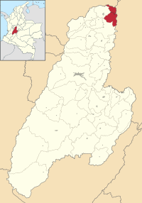
 Location of the municipality and town of Honda in Tolima Department. Location of the municipality and town of Honda in Tolima Department. | |
| Country | |
| Department | Tolima |
| Government | |
| • Mayor | Alberto Arce Camacho |
| Area | |
| • Municipality and town | 304.9 km (117.7 sq mi) |
| • Urban | 10.15 km (3.92 sq mi) |
| Elevation | 229 m (751 ft) |
| Population | |
| • Municipality and town | 24,693 |
| • Density | 81/km (210/sq mi) |
| • Urban | 23,658 |
| • Urban density | 2,300/km (6,000/sq mi) |
| Time zone | UTC-5 |
Honda (IPA: [onda]) is a town and municipality in the Tolima department of Colombia. The population of the municipality was 24,693 as of the census 2018. Along with Líbano, Honda is the seat of the Roman Catholic Diocese of Líbano-Honda. The main industries of Honda are tourism, fishing, and cattle-ranching.
Toponymy (name origin)
Honda takes its name from the Ondaimas, the indigenous people that inhabited the banks of the Magdalena River and the region where the city lies today.
Honda is called "the City of Bridges" with more than 40 of them on the rivers Magdalena, Gualí, Guarinó, and Quebrada Seca. It is also called the "City of Peace" as it escaped most of the violence of the 1950s.
History

Honda was founded on August 24, 1539 by Francisco Nuñez Pedroso. The "golden age" of the city was between 1850 and 1910 when the Magdalena river constituted the only means of transportation between the Caribbean coast and the inland city of Bogotá. The city was the main river port of the country and all the imported goods and articles arrived in Bogotá through the port of Honda.
Because of its historical importance, Honda was named a Pueblo Patrimonio (heritage town) of Colombia in 2010. As of March 2021, it is the only municipality in the Middle Magdalena Valley region that has been awarded this distinction.
Climate
| Climate data for Honda (Esperanza La), elevation 222 m (728 ft), (1981–2010) | |||||||||||||
|---|---|---|---|---|---|---|---|---|---|---|---|---|---|
| Month | Jan | Feb | Mar | Apr | May | Jun | Jul | Aug | Sep | Oct | Nov | Dec | Year |
| Mean daily maximum °C (°F) | 33.0 (91.4) |
33.2 (91.8) |
33.1 (91.6) |
32.7 (90.9) |
32.7 (90.9) |
33.6 (92.5) |
34.9 (94.8) |
35.5 (95.9) |
34.2 (93.6) |
32.4 (90.3) |
32.0 (89.6) |
32.3 (90.1) |
33.3 (91.9) |
| Daily mean °C (°F) | 27.5 (81.5) |
27.8 (82.0) |
27.7 (81.9) |
27.4 (81.3) |
27.4 (81.3) |
27.7 (81.9) |
28.6 (83.5) |
29.1 (84.4) |
28.5 (83.3) |
27.4 (81.3) |
27.0 (80.6) |
27.3 (81.1) |
27.7 (81.9) |
| Mean daily minimum °C (°F) | 22.1 (71.8) |
22.2 (72.0) |
22.4 (72.3) |
22.5 (72.5) |
22.5 (72.5) |
22.4 (72.3) |
21.9 (71.4) |
22.2 (72.0) |
22.2 (72.0) |
22.1 (71.8) |
22.1 (71.8) |
22.4 (72.3) |
22.2 (72.0) |
| Average precipitation mm (inches) | 51.2 (2.02) |
75.3 (2.96) |
117.9 (4.64) |
194.8 (7.67) |
178.1 (7.01) |
71.1 (2.80) |
57.3 (2.26) |
74.8 (2.94) |
140.2 (5.52) |
214.1 (8.43) |
211.1 (8.31) |
112.6 (4.43) |
1,498.5 (59.00) |
| Average precipitation days | 8 | 9 | 12 | 17 | 17 | 10 | 9 | 10 | 14 | 19 | 17 | 12 | 154 |
| Average relative humidity (%) | 76 | 75 | 76 | 79 | 78 | 73 | 67 | 65 | 71 | 78 | 80 | 80 | 75 |
| Mean monthly sunshine hours | 201.5 | 166.6 | 151.9 | 147.0 | 176.7 | 180.0 | 207.7 | 204.6 | 180.0 | 173.6 | 174.0 | 189.1 | 2,152.7 |
| Mean daily sunshine hours | 6.5 | 5.9 | 4.9 | 4.9 | 5.7 | 6.0 | 6.7 | 6.6 | 6.0 | 5.6 | 5.8 | 6.1 | 5.9 |
| Source: Instituto de Hidrologia Meteorologia y Estudios Ambientales | |||||||||||||
References
- ^ Citypopulation.de Population of Honda municipality with localities
- "HONDA: "Ciudad de la Paz", "Ciudad de los Puentes"" (in Spanish). Informativo Colombiano. Archived from the original on 5 February 2018. Retrieved 10 August 2016.
- "GUÍA: Red Turística de Pueblos Patrimonio de Colombia" (PDF). Fondo Nacional de Turismo de la República de Colombia - FONTUR. Dec 2020. Retrieved 29 Mar 2021.
- "Promedios Climatológicos 1981–2010" (in Spanish). Instituto de Hidrologia Meteorologia y Estudios Ambientales. Archived from the original on 15 August 2016. Retrieved 17 June 2024.
5°12′15″N 74°44′30″W / 5.20417°N 74.74167°W / 5.20417; -74.74167
This Colombian location article is a stub. You can help Misplaced Pages by expanding it. |