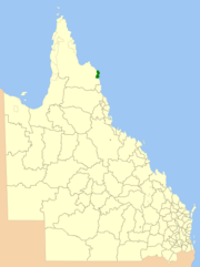
Local government area in Queensland, Australia
| Hope Vale Aboriginal Shire Queensland | |||||||||||||||
|---|---|---|---|---|---|---|---|---|---|---|---|---|---|---|---|
 Location within Queensland Location within Queensland | |||||||||||||||
| Coordinates | 15°17′46″S 145°06′43″E / 15.296°S 145.112°E / -15.296; 145.112 | ||||||||||||||
| Population | 976 (2021 census) | ||||||||||||||
| • Density | 0.8660/km (2.2430/sq mi) | ||||||||||||||
| Established | 1986 | ||||||||||||||
| Area | 1,127 km (435.1 sq mi) | ||||||||||||||
| Mayor | Jason Grant Woibo | ||||||||||||||
| Council seat | Hope Vale | ||||||||||||||
| Region | Far North Queensland | ||||||||||||||
| State electorate(s) | Cook | ||||||||||||||
| Federal division(s) | Leichhardt | ||||||||||||||
 | |||||||||||||||
| Website | Hope Vale Aboriginal Shire | ||||||||||||||
| |||||||||||||||
The Aboriginal Shire of Hope Vale is a local government area in Far North Queensland, Queensland, Australia, north of the town of Cooktown. The majority of the Shire consists of Deed of Grant land that is held for the benefit of Aboriginal people particularly concerned with the land and their ancestors and descendants.
In the 2021 census, the Hope Vale Aboriginal Shire had a population of 976 people, of whom 863 (88.4%) are Indigenous Australians.
History
Main articles: Cape Bedford Mission and Hope Vale, QueenslandGuugu Yimithirr (also known as Koko Yindjir, Gugu Yimidhirr, Guguyimidjir) is an Australian Aboriginal language of Hope Vale and the Cooktown area. The language region includes the local government area of the Aboriginal Shire of Hope Vale and the Shire of Cook, particularly the localities of Cape Bedford, Battle Camp and sections of the Normanby River and Annan River.
The area originally was set up as a German Lutheran mission in 1885 by missionaries, at what came to be known as the Cape Bedford Mission, 25 kilometres (16 mi) from what is now Hope Vale. The residents were evacuated to Woorabinda during World War II in 1942, and the land was used by the army. Many of the people died, and the survivors were not allowed to return until 1949. In September 1952, the land was formally gazetted as an Aboriginal reserve.
In 1986, under the Community Services (Aborigines) Act 1984, a Deed of Grant in Trust was given to the Hope Vale community. Like other DOGIT communities of the time, Hope Vale had a Community Council elected by Aboriginal people living in the community.
Demographics
In the 2016 census, the Hope Vale Aboriginal Shire had a population of 918 people, of whom 897 (92.0% are Indigenous Australians.
In the 2021 census, the Hope Vale Aboriginal Shire had a population of 976 people, of whom 863 (88.4%) are Indigenous Australians.
Responsibilities
The Hope Vale Aboriginal Shire Council operates under the requirements set out in the Queensland Local Government Act. However, in the township of Hope Vale the council is also the Trustee of the land and as such has added responsibilities that are quite different from a typical local government body. This includes responsibility for fisheries, alcohol management and employment initiatives.
The Hope Vale Aboriginal Shire Council operates an Indigenous Knowledge Centre (Nganthaanun-Milbi\Guugu Magubadaaygu), at the Jack Bambie Memorial Centre, in Hope Vale.
Mayors
| This list is incomplete; you can help by adding missing items. (December 2017) |
- 2008-2020 : Gregory Raymond McLean
- 2020–present: Jason Grant Woibo
See also
References
- ^ Australian Bureau of Statistics (28 June 2022). "Hope Vale Aboriginal Shire (LGA)". 2021 Census QuickStats. Retrieved 28 February 2023.

- "Layers: Locality; Local government". Queensland Globe. Queensland Government. Archived from the original on 19 December 2017. Retrieved 10 July 2024.
-
 This Misplaced Pages article incorporates CC BY 4.0 licensed text from: "Guugu Yimithirr". Queensland Aboriginal and Torres Strait Islander languages map. State Library of Queensland. Retrieved 28 January 2020.
- Australian Bureau of Statistics (27 June 2017). "Hope Vale Aboriginal Shire (LGA)". 2016 Census QuickStats. Retrieved 20 October 2018.

- "Hope Vale Aboriginal Shire Council". Public Libraries Connect. State Library of Queensland. 20 September 2016. Archived from the original on 3 February 2018. Retrieved 2 February 2018.
- "2008 Hope Vale Aboriginal Shire Council - Mayoral Election - Election Summary". results.ecq.qld.gov.au. Archived from the original on 27 April 2018. Retrieved 4 December 2017.
- "2012 Hope Vale Aboriginal Shire Council - Mayoral Election - Election Summary". results.ecq.qld.gov.au. Archived from the original on 1 April 2018. Retrieved 4 December 2017.
- "2016 Hope Vale Aboriginal Shire Council - Mayoral Election - Election Summary". results.ecq.qld.gov.au. Archived from the original on 27 March 2018. Retrieved 4 December 2017.
- "2020 Local Government Elections: Saturday, 28 March 2020". Electoral Commission of Queensland. 2020. Retrieved 16 June 2020.
External links
| Towns and localities in the Aboriginal Shire of Hope Vale, Queensland | |
|---|---|
| Main Article: Local government areas of Queensland |
| Local government areas of Queensland | |
|---|---|
| South East | |
| Wide Bay–Burnett | |
| Darling Downs | |
| Central | |
| North | |
| Far North | |
| North West | |
| Central West | |
| South West | |