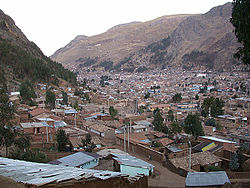
| Huancavelica Wankawillka | |
|---|---|
| District | |
 Huancavelica Huancavelica | |
 Flag Flag Coat of arms Coat of arms | |
| Country | |
| Region | Huancavelica |
| Province | Huancavelica |
| Capital | Huancavelica |
| Government | |
| • Mayor | Rómulo Cayllahua Paytán (2019–2022) |
| Area | |
| • Total | 514.1 km (198.5 sq mi) |
| Elevation | 3,660 m (12,010 ft) |
| Population | |
| • Total | 39,776 |
| • Density | 77/km (200/sq mi) |
| Time zone | UTC-5 (PET) |
| UBIGEO | 090101 |
Huancavelica District is one of nineteen districts of the province Huancavelica in Peru.
Geography
The Chunta mountain range traverses the district. Some of the highest mountains of the district are listed below:
- Hatun Pirwayuq
- Hatun Q'asa
- Huch'uy Pirwayuq
- Kachi Mach'ay Urqu
- Kuntur Wamani
- Pinqullu
- Puka Q'asa
- Puka Urqu
- Puywan
- Qarwa K'anti
- Qarwa Urqu
- Qarwarasu
- Qucha Q'asa
- Tiklla Q'asa
- Ukhu P'ukru
- Wachu Intiyuq
- Wamanrasu
- Waqutuyuq
- Wayq'u Kancha
- Yana Kancha
See also
References
- (in Spanish) Instituto Nacional de Estadística e Informática. Banco de Información Distrital Archived 2008-04-23 at the Wayback Machine. Retrieved April 11, 2008.
- escale.minedu.gob.pe/ UGEL map Huancavelica Province 1 (Huancavelica Region)
| |
|---|---|
| Acobamba | |
| Angaraes | |
| Castrovirreyna | |
| Churcampa | |
| Huancavelica | |
| Huaytará | |
| Tayacaja | |
This Huancavelica Region geography article is a stub. You can help Misplaced Pages by expanding it. |
12°47′14″S 74°58′23″W / 12.7873°S 74.9731°W / -12.7873; -74.9731
Categories: