| Immokalee Regional Airport (former Immokalee Army Airfield) | |||||||||||||||
|---|---|---|---|---|---|---|---|---|---|---|---|---|---|---|---|
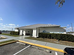
 General aviation terminal in 2021 General aviation terminal in 2021 | |||||||||||||||
| Summary | |||||||||||||||
| Airport type | Public | ||||||||||||||
| Owner | Collier County Airport Authority | ||||||||||||||
| Serves | Immokalee, Florida | ||||||||||||||
| Elevation AMSL | 37 ft / 11 m | ||||||||||||||
| Coordinates | 26°26′02″N 81°24′05″W / 26.43389°N 81.40139°W / 26.43389; -81.40139 | ||||||||||||||
| Website | www.CollierGov.net/... | ||||||||||||||
| Map | |||||||||||||||
  | |||||||||||||||
| Runways | |||||||||||||||
| |||||||||||||||
| Statistics (2019) | |||||||||||||||
| |||||||||||||||
| Source: Federal Aviation Administration | |||||||||||||||
Immokalee Regional Airport (IATA: IMM, ICAO: KIMM, FAA LID: IMM) is a public use airport located one nautical mile (2 km) northeast of the central business district of Immokalee, in Collier County, Florida, United States. The airport is owned by the Collier County Airport Authority. Formerly known as Immokalee Airport, it is included in the National Plan of Integrated Airport Systems for 2011–2015, which categorized it as a general aviation facility.
History
The Immokalee Regional Airport was established as Immokalee Army Airfield, and activated on July 5, 1942. It was assigned to United States Army Air Forces East Coast Training Center (later Eastern Training Command). It was an auxiliary to Hendricks Army Airfield and was an AAF Specialized Pilot Training School (4-Engine) for B-17 and B-24 heavy bombers. The airfield also provided flexible gunnery training for Buckingham Army Airfield near Fort Myers.
It was transferred to Third Air Force in July 1944 with the drawdown of AAFTC's pilot training program and was a group training facility for replacement personnel. It became an auxiliary of the Sarasota Army Airfield replacement fighter pilot training school.
The airfield was declared surplus and turned over to the Army Corps of Engineers on September 30, 1945. It was eventually discharged to the War Assets Administration and became a civil airport.
Facilities and aircraft
Immokalee Regional Airport covers an area of 1,330 acres (538 ha) at an elevation of 37 feet (11 m) above mean sea level. It has two asphalt paved runways, designated 9/27 and 18/36. 9/27 is 5,000 x 100 feet (1,524 x 30 m) and 18/36 is 4,550 x 150 feet (1,387 x 46 m).
For the 12-month period ending February 28, 2019, the airport had 37,700 general aviation aircraft operations, and 150 military operations, an average of 104 per day. At that time there were 31 aircraft based at this airport: 24 single-engine, 6 multi-engine, and 1 helicopter.
See also
References
- ^ FAA Airport Form 5010 for IMM PDF. Federal Aviation Administration. Effective October 14, 2023.
- "Immokalee Regional Airport" (PDF). Florida Department of Transportation CFASPP. Retrieved August 3, 2013.
- "Immokalee Regional Airport". Collier County. Retrieved August 3, 2013.
- "IATA Airport Code Search (IMM: Immokalee)". International Air Transport Association. Retrieved August 3, 2013.
- "KIMM – Immokalee Airport". FAA data republished by AirNav. March 12, 2009. Archived from the original on April 13, 2009.
- "2011–2015 NPIAS Report, Appendix A" (PDF). National Plan of Integrated Airport Systems. Federal Aviation Administration. October 4, 2010. Archived from the original (PDF, 2.03 MB) on September 27, 2012.
- ^ "Community of Immokalee". Florida Heartland ERO. Retrieved August 19, 2023.
- Lobb, Justin. "Collier County Airports: A Gateway to Florida's Paradise Coast". Florida Department of Transportation Aviation Office. Retrieved August 19, 2023.
-
 This article incorporates public domain material from the Air Force Historical Research Agency
- Manning, Thomas A. (2005), History of Air Education and Training Command, 1942–2002. Office of History and Research, Headquarters, AETC, Randolph AFB, Texas OCLC 71006954, 29991467
- Shaw, Frederick J. (2004), Locating Air Force Base Sites, History’s Legacy, Air Force History and Museums Program, United States Air Force, Washington DC. OCLC 57007862, 1050653629
External links
 Media related to Immokalee Regional Airport at Wikimedia Commons
- Immokalee Regional Airport at Collier County website
- "Immokalee Regional Airport". brochure from CFASPP
- Aerial image as of February 1999 from USGS The National Map
- FAA Terminal Procedures for IMM, effective November 28, 2024
- Resources for this airport:
- FAA airport information for IMM
- AirNav airport information for KIMM
- ASN accident history for IMM
- FlightAware airport information and live flight tracker
- SkyVector aeronautical chart for KIMM