| Ingwierrum | |
|---|---|
| Village | |
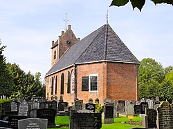
 Ingwierrum church Ingwierrum church | |
 Flag Flag Coat of arms Coat of arms | |
 Location in the former Dongeradeel municipality Location in the former Dongeradeel municipality | |
  | |
| Coordinates: 53°19′11″N 6°8′12″E / 53.31972°N 6.13667°E / 53.31972; 6.13667 | |
| Country | |
| Province | |
| Municipality | Noardeast-Fryslân |
| Area | |
| • Total | 12.32 km (4.76 sq mi) |
| Elevation | 1.1 m (3.6 ft) |
| Population | |
| • Total | 540 |
| • Density | 44/km (110/sq mi) |
| Postal code | 9132 |
| Dialing code | 0519 |
Ingwierrum (Dutch: Engwierum) is a village in Noardeast-Fryslân in the province of Friesland, the Netherlands. It had a population of approximately 565 in January 2017. Before 2019, the village was part of the Dongeradeel municipality.
History
The village was first mentioned in 1447 as Edygwerum, and means "settlement on the terp of the people of Ede (person)." Ingwierrum is a terp (artificial living mound) village from the early middle ages. The Dutch Reformed church has a possibly 13th century tower which was enlarged in the 14th century. The church building dates from 1746.
In 1719, Ingwierrum was hit by a flood, and the decision was made to dam the Dokkumer Grootdiep. In 1729, an obelisk was placed in Ingwierrum as a monument to the closure of the dike. The locks were restored in 1834. In 1840, Ingwierrum was home to 681 people.
The village's official name was changed from Engwierum to Ingwierrum in 2023.
Gallery
References
- ^ "Kerncijfers wijken en buurten 2021". Central Bureau of Statistics. Retrieved 31 March 2022.
two entries
- "Postcodetool for 9132EA". Actueel Hoogtebestand Nederland (in Dutch). Het Waterschapshuis. Retrieved 31 March 2022.
- Aantal inwoners per woonplaats in Dongeradeel op 1 januari 2017 Archived 2017-10-21 at the Wayback Machine - Dongeradeel
- ^ "Engwierum". Plaatsengids (in Dutch). Archived from the original on 15 August 2022. Retrieved 31 March 2022.
- "Engwierum - (geografische naam)". Etymologiebank (in Dutch). Retrieved 31 March 2022.
- ^ Ronald Stenvert & Sabine Broekhoven (2000). "Engwierum" (in Dutch). Zwolle: Waanders. ISBN 90 400 9476 4. Retrieved 31 March 2022.
- "Monumentnummer: 23753". Dutch Monuments Register (in Dutch). Retrieved 31 March 2022.
- "22 dorpen in Noardeast-Fryslân krijgen op 1 januari 2023 een nieuwe Friese naam" [22 villages in Noardeast-Fryslân will receive a new Frisian name on 1 January 2023]. RTV NOF (in Dutch). 10 December 2022. Retrieved 7 April 2023.
- "Friese namen" [Frisian names]. Taalunie (in Dutch). Retrieved 7 April 2023.
External links
![]() Media related to Ingwierrum at Wikimedia Commons
Media related to Ingwierrum at Wikimedia Commons
This Friesland location article is a stub. You can help Misplaced Pages by expanding it. |


