| Itabu Station 飯給駅 | |||||||||||
|---|---|---|---|---|---|---|---|---|---|---|---|
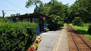
 The station platform and waiting room in July 2015 The station platform and waiting room in July 2015 | |||||||||||
| General information | |||||||||||
| Location | Ichihara, Chiba Japan | ||||||||||
| Operated by | Kominato Railway | ||||||||||
| Line(s) | Kominato Line | ||||||||||
| History | |||||||||||
| Opened | 1926 | ||||||||||
| Passengers | |||||||||||
| FY2010 | 6 daily | ||||||||||
| Services | |||||||||||
| |||||||||||
Itabu Station (飯給駅, Itabu-eki) is a railway station on the Kominato Line in Ichihara, Chiba, Japan, operated by the third-sector railway operator Kominato Railway.
Lines
Itabu Station is served by the Kominato Railway Kominato Line, and lies 27.5 km from the western terminus of the line at Goi Station.
Station layout
Itabu Station has a single side platform serving bidirectional traffic. The station is unstaffed, but there is a small shelter on the platform.
Platforms
| - | ■ Kominato Line | for Kazusa-Ushiku and Goi for Kazusa-Nakano |
History
Itabu Station opened on September 1, 1926. It has been unstaffed since 5 January 1956.
Passenger statistics
In fiscal 2010, the station was used by an average of 6 passengers daily (boarding passengers only).
Surrounding area
Adjacent to the station is what is dubbed "the largest public lavatory in the world". Designed by Japanese architect Sou Fujimoto and completed in 2012, the facility for women only consists of a single glass toilet cubicle located inside a 200 square metre enclosure.
-
The enclosure surrounding the women's toilet, July 2015
-
Inside the women's toilet, July 2015
-
The unisex toilet, July 2015
See also
References
- ^ Terada, Hirokazu (19 January 2013). データブック日本の私鉄 [Databook: Japan's Private Railways]. Japan: Neko Publishing. p. 208. ISBN 978-4-7770-1336-4.
- Ryall, Julian (15 May 2012). "Japan's loo with a view is world's largest too". The Telegraph (in Japanese). Japan: Telegraph Media Group Limited. Retrieved 12 November 2014.
External links
- Official website (in Japanese)
| Stations of the Kominato Railway Kominato Line | |
|---|---|
35°19′14.44″N 140°08′32.04″E / 35.3206778°N 140.1422333°E / 35.3206778; 140.1422333

