| Borough of Jenkintown | |
|---|---|
| Borough | |
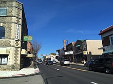
 View entering Jenkintown from Wyncote View entering Jenkintown from Wyncote | |
 Keystone Marker Keystone Marker | |
| Interactive map outlining Jenkintown, PA | |
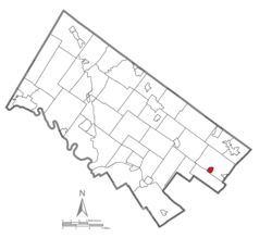
 Location of Jenkintown in Montgomery County, Pennsylvania Location of Jenkintown in Montgomery County, Pennsylvania | |
  | |
| Coordinates: 40°05′46″N 75°07′34″W / 40.096°N 75.126°W / 40.096; -75.126 | |
| Country | United States |
| State | Pennsylvania |
| County | Montgomery |
| Incorporated | December 8, 1874 |
| Government | |
| • Type | Council-manager |
| • Mayor | Gabriel Lerman |
| Area | |
| • Total | 0.59 sq mi (1.52 km) |
| • Land | 0.59 sq mi (1.52 km) |
| • Water | 0.00 sq mi (0.00 km) |
| Elevation | 322 ft (98 m) |
| Population | |
| • Total | 4,719 |
| • Density | 8,052.90/sq mi (3,106.87/km) |
| Time zone | UTC-5 (EST) |
| • Summer (DST) | UTC-4 (EDT) |
| ZIP Code | 19046 |
| Area codes | 215, 267 and 445 |
| FIPS code | 42-38000 |
| Website | jenkintownboro |
Jenkintown is a borough in Montgomery County, Pennsylvania. It is approximately 10 mi (16 km) north of Center City Philadelphia.
History
| This section relies largely or entirely on a single source. Relevant discussion may be found on the talk page. Please help improve this article by introducing citations to additional sources. Find sources: "Jenkintown, Pennsylvania" – news · newspapers · books · scholar · JSTOR (April 2016) |
The community was named for William Jenkins, a Welsh pioneer settler.
Jenkintown is located just outside Philadelphia along the Route 611 corridor between Abington and Cheltenham Townships. The borough was settled in about 1697 and incorporated on December 8, 1874, when approximately 248 acres (1.00 km) was taken from Abington Township. Today, the Borough is approximately 0.58 square miles (1.5 km) and is home to 4,500 residents.
The borough is a mostly residential community that is separated into East and West by the Business District that runs along and surrounds Old York Road (Route 611) corridor. On the east side of Old York Road, residential development is predominantly characterized by larger detached single-family homes on lots larger than the Borough average. On the southeast side of York Road, there is a small mixed concentration of row homes, duplexes, and single-family residences. The majority of the residential development, however, is located to the west of York Road. This area consists of a traditional small town mix of detached single-family homes, duplexes, and row homes. Located throughout this area are several multi-family apartment buildings that are residential condominium or rental properties. At the center of this residential area are the Jenkintown Elementary School and the Jenkintown High School.
The Jenkintown Fire Department consists of two fire companies founded more than 125 years ago. The Jenkintown Fire Department is a totally volunteer department consisting of the Pioneer Fire Company #1 and the Independent Fire Company #2. The Pioneer Company was organized in 1884 and the Independent Company was organized in 1889, an artifact of the historical split between Catholics and Protestants in the population of the borough. The two fire companies have a total membership of approximately 150, with 50 members composing the active firefighting crew.
Elements of the British army passed through Jenkintown en route to the Battle of White Marsh in early December 1777.
The Jenkins' Town Lyceum Building, Jenkintown-Wyncote station, and Strawbridge and Clothier Store are listed on the National Register of Historic Places.
Retail hub

From the mid-1950s until the early 1980s, Jenkintown was a major retail hub for the northern suburbs of Philadelphia.
The stretch of Old York Road from Lord & Taylor just south of Jenkintown up to the Sears in Abington Township was sometimes called the Golden 2½ Miles. Five major department stores lined Old York Road:
- Bonwit Teller at the "Avenue of Shops", #500, a row of small shops fronting the road, with Bonwit's, opened in 1955, at its northern end. Federated Department Stores leased the site in June 1971, added a floor and converted the entire, larger building to a Bloomingdale's home furnishings store which opened in August 1972. Bonwit Teller relocated nearby, still in Jenkintown, which closed along with the rest of the chain in 1990.
- Lord & Taylor at #323 - nearby was the Benjamin Fox Pavilion, a 300,000-square-foot (28,000 m) office and retail complex
- Strawbridge & Clothier at #610, now called Jenkins Court and listed on the National Register of Historic Places. opened in 1931 as one of the first suburban branch department stores in the country. Moved to Willow Grove Park Mall in 1988.
- Sears at #1495 in Abington, which moved to the Willow Grove Park Mall in 1987.
- Wanamaker's at #901 in Abington Township, opened 1958. In 1999, the site was renamed Noble Town Center and is now a power center.
Geography
Jenkintown borough is located at 40°5′46″N 75°7′46″W / 40.09611°N 75.12944°W / 40.09611; -75.12944 (40.096060, -75.129415). According to the U.S. Census Bureau, the borough has a total area of 0.6 square miles (1.6 km), all land. Jenkintown is surrounded by Abington Township to the north, west, and east, and borders Cheltenham Township to the south.
Education
Further information: Jenkintown School DistrictThe Jenkintown School District includes Jenkintown Elementary School and Jenkintown Middle/High School. The district has an enrollment of over 700 students.
St. Joseph the Protector Regional Catholic School in Glenside and Abington Township is the area Catholic school. It was formed in 2012 by the merger of Immaculate Conception School in Jenkintown and St. Luke the Evangelist School in Glenside.
Abington Friends School is an independent Quaker school in nearby Abington Township, serving students from age 3 to grade 12. Abington Friends School has stood on its original campus in Abington Township since 1697.
Manor College is in Abington Township, with a Jenkintown mailing address. The college founded in 1947, is a private Catholic college founded by the Byzantine Ukrainian Sisters of Saint Basil the Great. It is affiliated with the Ukrainian Greek Catholic Church.
Demographics
| Census | Pop. | Note | %± |
|---|---|---|---|
| 1880 | 810 | — | |
| 1890 | 1,609 | 98.6% | |
| 1900 | 2,091 | 30.0% | |
| 1910 | 2,968 | 41.9% | |
| 1920 | 3,366 | 13.4% | |
| 1930 | 4,797 | 42.5% | |
| 1940 | 5,024 | 4.7% | |
| 1950 | 5,130 | 2.1% | |
| 1960 | 5,017 | −2.2% | |
| 1970 | 5,404 | 7.7% | |
| 1980 | 4,942 | −8.5% | |
| 1990 | 4,574 | −7.4% | |
| 2000 | 4,478 | −2.1% | |
| 2010 | 4,422 | −1.3% | |
| 2020 | 4,719 | 6.7% | |
As of the 2010 census, the borough was 87.5% White, 5.7% Black or African American, 2.0% Asian, and 1.8% were two or more races. 3.0% of the population were of Hispanic or Latino ancestry.
As of the census of 2000, there were 4,478 people, 2,035 households, and 1,088 families residing in the borough. The population density was 7,844.0 inhabitants per square mile (3,028.6/km). There were 2,085 housing units at an average density of 3,652.2 per square mile (1,410.1/km). The racial makeup of the borough was 93.61% White, 4.00% African American, 0.04% Native American, 0.94% Asian, 0.02% Pacific Islander, 0.49% from other races, and 0.89% from two or more races. Hispanic or Latino of any race were 1.30% of the population.
There were 2,035 households, out of which 24.3% had children under the age of 18 living with them, 42.2% were married couples living together, 8.6% had a female householder with no husband present, and 46.5% were non-families. 40.6% of all households were made up of individuals, and 19.3% had someone living alone who was 65 years of age or older. The average household size was 2.19 and the average family size was 3.08.
The age distribution of the borough's population is spread out, with 22.9% under the age of 18, 5.6% from 18 to 24, 27.0% from 25 to 44, 23.5% from 45 to 64, and 21.0% who were 65 years of age or older. The median age was 42 years. For every 100 females, there were 78.9 males. For every 100 females age 18 and over, there were 73.2 males.
The median income for a household in the borough was $47,743, and the median income for a family was $72,902. Males had a median income of $41,970 versus $35,625 for females. The per capita income for the borough was $29,834. About 1.9% of families and 5.1% of the population were below the poverty line, including 3.6% of those under age 18 and 7.2% of those age 65 or over.
Transportation
Highways and roads


As of 2017 there were 12.30 miles (19.79 km) of public roads in Jenkintown, of which 1.50 miles (2.41 km) were maintained by the Pennsylvania Department of Transportation (PennDOT) and 10.80 miles (17.38 km) were maintained by the borough.
PA Route 611 heads north–south through Jenkintown along Old York Road, heading south to Philadelphia and north to Willow Grove, where it has an interchange with the Pennsylvania Turnpike and Doylestown. PA Route 73 passes east–west along the southern edge of Jenkintown along Washington Lane and Township Line Road, heading west to Wyncote and east to Northeast Philadelphia. Greenwood Avenue runs east–west through the center of Jenkintown, heading west to Wyncote.
Trains and buses

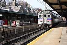
The Jenkintown-Wyncote station is one of SEPTA's major Regional Rail stops; the Lansdale/Doylestown Line, Warminster Line, and West Trenton Line regional rail services all stop there. Jenkintown-Wyncote station is the busiest SEPTA Regional Rail station outside the city of Philadelphia. The Jenkintown-Wyncote station building with its Queen Anne-style architecture was designed by famous Philadelphia architect Horace Trumbauer. SEPTA provides City Bus service to Jenkintown along Route 55, which follows PA 611 south to Olney Transportation Center in North Philadelphia and north to Willow Grove and Doylestown, and Route 77, which heads west to the Chestnut Hill section of Philadelphia and east to Northeast Philadelphia.
Politics and government
| Year | Republican | Democratic |
|---|---|---|
| 2020 | 19.7% 619 | 79.1% 2,481 |
| 2016 | 20.6% 563 | 74.9% 2,052 |
| 2012 | 27.1% 724 | 71.4% 1,905 |
| 2008 | 25.1% 708 | 73.8% 2,079 |
| 2004 | 28.6% 832 | 71.0% 2,068 |
| 2000 | 29.9% 791 | 65.7% 1,734 |

Jenkintown has a city manager form of government with a mayor and a twelve-member borough council. The current mayor is Gabriel Lerman. Jay Conners is the President of Borough Council, and Christian Soltysiak is vice president.
The borough is part of the Fourth Congressional District, represented by Madeleine Dean. At the state level, Jenkintown is part of the Pennsylvania's 154th Representative District, represented by Napoleon Nelson, and the 4th Senatorial District, represented by Arthur L. Haywood III. All are Democrats. Jenkintown, like its surroundings of Abington and Cheltenham and their included towns, votes overwhelmingly Democratic.
In popular culture
The television sitcom The Goldbergs is set in Jenkintown; it is based on the 1980s childhood of show creator Adam F. Goldberg, a Jenkintown native.
Notable people
- Bryan Cohen, American-Israeli basketball player
- Bradley Cooper, actor and filmmaker
- Lawrence Curry, educator and politician
- Adam F. Goldberg, television and film producer; creator of The Goldbergs, which is set in Jenkintown
- David Hungerford, cancer researcher, died in Jenkintown
- Mary Frances Lovell, writer, humanitarian, and temperance reformer
- George Low Jr., professional golfer
- George Low Sr., professional golfer
- Carol Polis, professional boxing judge
- Ezra Pound, poet and critic
- Lessing J. Rosenwald, former chairman and president of Sears
- Max Ritter, Olympic swimmer
- Allyson Schwartz, politician
References
- "ArcGIS REST Services Directory". United States Census Bureau. Retrieved October 12, 2022.
- ^ "Census Population API". United States Census Bureau. Retrieved Oct 12, 2022.
- "Jenkintown". Visit Pennsylvania. September 25, 2022.
- "National Register Information System". National Register of Historic Places. National Park Service. July 9, 2010.
- ^ Old York Historical Society (2000). Abington, Jenkintown, and Rockledge. Arcadia Publishing. pp. 38–39. ISBN 978-0-7385-0473-5. Retrieved 8 November 2023.
The Avenue of Shops was a series of small shops, anchored at the northern end by Bonwit Teller, which was built and opened in 1955. Along with the presence of the Strawbridge & Clothier and John Wanamaker stores nearby, the Avenue of Shops helped make Jenkintown a shopping mecca for the approximately 15 years it was in existence. On June 1, 1971, Federated Department Stores leased the site and announced that the first Bloomingdale's store in Pennsylvania would open within a year. A second story was added for the entire length of the structure, and the store occupied the whole complex. In August 1982, Bloomingdale's moved to the new Willow Grove Park Mall, and the building was sold to the Nutrisystems Corporation. Later, Zany Brainy occupied the corner store, and the remainder of the building was devoted to professional offices.
- ^ Anderson, Laurie Halse (12 April 1990). "Out of fashion: shopping district fades as Bonwit Teller quits". The Philadelphia Inquirer. p. 163. Retrieved 8 November 2023.
- June 6, 2021. “Noble Town Center sells for $14 million”. The Reporter.
- "US Gazetteer files: 2010, 2000, and 1990". United States Census Bureau. 2011-02-12. Retrieved 2011-04-23.
- "About Us". The School District of Jenkintown. May 13, 2015.
- "2012 Catholic grade school consolidations/closings". Catholicphilly.com. 2012-07-15. Retrieved 2020-04-22.
- "Zoning". Abington Township. Retrieved 2024-03-11. - Abington Friends School is at F5, indicated with "▲1".
- "2020 CENSUS - CENSUS BLOCK MAP: Abington township, PA" (PDF). U.S. Census Bureau. p. 2 (PDF p. 3/4). Retrieved 2024-02-06.
Manor Colg
- "Home". Manor College. Retrieved 2024-02-06.
Manor College 700 Fox Chase Road, Jenkintown, PA 19046
- Despite the address, it is not in Jenkintown Borough. - "Census 2020".
- "Archived copy". USA Today. Archived from the original on 2012-02-15. Retrieved 2017-09-01.
{{cite web}}: CS1 maint: archived copy as title (link) - "U.S. Census website". United States Census Bureau. Retrieved 2008-01-31.
- "Jenkintown Borough map" (PDF). PennDOT. Retrieved March 10, 2023.
- Montgomery County, Pennsylvania (Map) (18th ed.). 1"=2000'. ADC Map. 2006. ISBN 0-87530-775-2.
- ^ SEPTA Official Transit & Street Map Suburban (PDF) (Map). SEPTA. Archived from the original (PDF) on April 7, 2016. Retrieved May 2, 2016.
- "SEPTA (May 2014). Fiscal Year 2015 Annual Service Plan. p. 61" (PDF). Archived from the original (PDF) on 2014-08-12. (539 KB)
- "Montgomery County Election Results". Montgomery County, Pennsylvania. Retrieved January 16, 2017.
- Archived at Ghostarchive and the Wayback Machine: "Going home with Bradley Cooper". YouTube.
- Neil Stook, The Life of Ezra Pound (2011), page 5
External links
| Places adjacent to Jenkintown, Pennsylvania | |
|---|---|
| Jenkintown, Pennsylvania | |
|---|---|
| Education |
|
| Landmarks | |
| Transportation | |
| This list is incomplete. | |
