| Junglinster Jonglënster (Luxembourgish) | |
|---|---|
| Commune | |
 | |
 Coat of arms Coat of arms | |
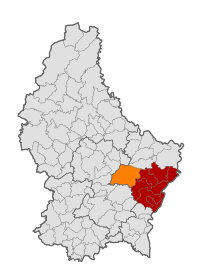
 Map of Luxembourg with Junglinster highlighted in orange, and the canton in dark red Map of Luxembourg with Junglinster highlighted in orange, and the canton in dark red | |
| Coordinates: 49°42′40″N 6°15′05″E / 49.7111°N 6.2514°E / 49.7111; 6.2514 | |
| Country | |
| Canton | Grevenmacher |
| Government | |
| • Mayor | Bernard Ries |
| Area | |
| • Total | 55.38 km (21.38 sq mi) |
| • Rank | 6th of 100 |
| Highest elevation | 411 m (1,348 ft) |
| • Rank | 41st of 100 |
| Lowest elevation | 243 m (797 ft) |
| • Rank | 53rd of 100 |
| Population | |
| • Total | 8,622 |
| • Rank | 18th of 100 |
| • Density | 160/km (400/sq mi) |
| • Rank | 53rd of 100 |
| Time zone | UTC+1 (CET) |
| • Summer (DST) | UTC+2 (CEST) |
| LAU 2 | LU0001105 |
| Website | www.junglinster.lu |
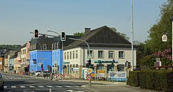
Junglinster (Luxembourgish: Jonglënster) is a commune in central Luxembourg, which draws its name from its principal town, Junglinster. It is one of six communes in the Luxembourg canton of Grevenmacher. The 18th-century St Martin's church is a national monument.
History
The oldest mention of Lincera (the "linster" part of the place name) is in documents going back to 983, with the status of parish first attested in 1128.
Population
As of 2024, the town of Junglinster has a population of 3,697, whilst the wider commune of Junglinster has a population of 8,622. Figures from 2018 report that 64.11% of the population of the commune holds Luxembourgish nationality, with the five largest immigrant populations in the commune being those of Portuguese (7.77%), French (5.12%), German (3.88%), Belgian (3.27%) and British (1.91%) nationalities.
| Graphs are unavailable due to technical issues. Updates on reimplementing the Graph extension, which will be known as the Chart extension, can be found on Phabricator and on MediaWiki.org. |
Transmitters
The commune hosts two of the world's most powerful longwave transmitters, with the older transmitter based just north of the town of Junglinster since 1933, and a more powerful longwave transmitter located in Beidweiller since 1972. These transmitters were utilised by Radio Luxembourg, which gained iconic status amongst audiences in Britain and Ireland in the 1930s and again in the 1960s and 1970s, for popular programmes that circumvented restrictive broadcasting laws, particularly in the UK. This gave Junglinster an important role in the history of pirate radio. The transmitters are in still in use by RTL (French radio).

Populated places
The commune consists of the following towns and villages:
|
|
Notable people
- Eugène Schaus (1901–1978), a Luxembourgish politician and jurist.
- Lex Jacoby (1930 in Junglister – 2015), writer; winner of the Servais Prize for Literature
Twin towns – sister cities
See also: List of twin towns and sister cities in SlovakiaJunglinster is twinned with:
References
- Alex Langini, L'Église Saint-Martin: Un chef-d'oeuvre baroque (undated booklet), citing E. Donckel, Die Kirche in Luxemburg von den Anfängen bis zur Gegenwart (Luxembourg, 1950), pp. 13-14.
- "Registre national des personnes physiques RNPP : Population par localité". data.public.lu. 2024-01-07.
- "Notre commune - Junglinster". junglinster.lu (in French). Retrieved 27 January 2019.
- "Population par canton et commune". statistiques.public.lu. Archived from the original on 12 September 2016. Retrieved 11 January 2022.
- "Junglinster" (in German). Üdersdorf. Retrieved 2019-09-08.
- "La Crosse gains 8th sister city: Junglinster, Luxembourg". 18 January 2023.
External links
 Media related to Junglinster at Wikimedia Commons
- (in French) Commune of Junglinster official website
| Places adjacent to Junglinster | ||||||||||||||||
|---|---|---|---|---|---|---|---|---|---|---|---|---|---|---|---|---|
| ||||||||||||||||
This article related to the geography of Grevenmacher canton is a stub. You can help Misplaced Pages by expanding it. |