| This article needs additional citations for verification. Please help improve this article by adding citations to reliable sources. Unsourced material may be challenged and removed. Find sources: "Kadampuzha" – news · newspapers · books · scholar · JSTOR (August 2016) (Learn how and when to remove this message) |
| Kadampuzha | |
|---|---|
| Small town | |
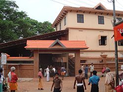
 Kadampuzha Temple Kadampuzha Temple | |
| Coordinates: 10°56′0″N 76°2′0″E / 10.93333°N 76.03333°E / 10.93333; 76.03333 | |
| Country | |
| State | Kerala |
| District | Malappuram |
| Government | |
| • Body | Marakara Panchayat |
| Languages | |
| • Official | Malayalam, English |
| Time zone | UTC+5:30 (IST) |
| Vehicle registration | KL-55 |
| Lok Sabha constituency | Ponnani |
| Nearest city | Malappuram |
Kadampuzha is a small town and a pilgrimage centre in Malappuram district of Kerala situated near the Thrissur-Calicut national highway.
Kadampuzha Temple
This village is known for Kadampuzha Devi Temple believed to have been consecrated by Adi Shankara . Situated in Marakkara grama Panchayath, Kadampuzha is 2.7 km away from Vettichira on the Thrissur-Calicut national highway.
Etymology
"Kadampuzha" got its name originated from "Kadan"(Forest dweller), "Ambu"(Arrow), "Azha"(Stream). The deity of the temple is goddess VanaDurga.
Festivals
Though the temple is famous all over the state of Kerala, there is no major festival associated with the temple. on Thrikkarthika day(Karthika Day of Malayalam month Vrishchikam), usually in November/December the birthday of goddess is celebrated in a huge manner.
Culture
Kadampuzha village is a moderately Muslim populated area. Hindus are exist in comparatively lesser numbers. So the culture of the locality is based upon heterogeneous manner.
Transportation
Kadampuzha village connects to other parts of India through Kottakkal town. National highway No.66 passes through Tanur and the northern stretch connects to Bangalore and Mumbai. The southern stretch connects to Cochin and Trivandrum. State Highway No.28 starts from Nilambur and connects to Ooty, Mysore and Bangalore through Highways.12,29 and 181. National Highway No.966 connects to Palakkad and Coimbatore. The nearest airport is at Kozhikode. The nearest major railway stations are in Kuttippuram (17KM) and Tirur (18KM). The town 'vettichira' 2.7 km away from kadampuzha help to get bus to kozhikkode, kannur and also to south districts of malappuram such as Trissur, ernamkulam.....etc
See also
References
- "Malappuram News, Malappuram District Map, Malappuram Muslim, Malappuram Hospitals, Malappuram College, Malappuram Directory". Archived from the original on 1 April 2016. Retrieved 14 July 2016.
| District of Malappuram | |
|---|---|
| Taluks | |
| Blocks | |
| Municipalities | |
| Villages | |
| History | |
| Administration | |
| Transport | |
| Tourism |
|
| Education |
|
| Urban Agglomeration | |
| Notable people | List of people from Malappuram district |
This article related to a location in Malappuram district, Kerala, India is a stub. You can help Misplaced Pages by expanding it. |