| Kalaallit Nunaat Arctic Steppe | |
|---|---|
 Narsarsuaq, Greenland on the southwest coast Narsarsuaq, Greenland on the southwest coast | |
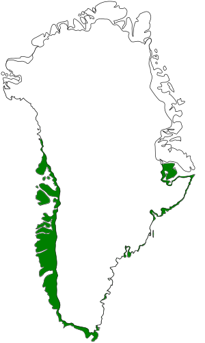
 Ecoregion territory (in green) Ecoregion territory (in green) | |
| Ecology | |
| Realm | Nearctic |
| Biome | Tundra |
| Borders | Kalaallit Nunaat high arctic tundra |
| Geography | |
| Area | 171,411 km (66,182 sq mi) |
| Country | Denmark |
| State | Greenland |
The Kalaallit Nunaat Arctic Steppe (Kalaallit Nunaat low arctic tundra) ecoregion covers the low coastal areas of western and southern Greenland, reaching in up to 100 km before bare rock and ice become dominant. While much of the ecoregion is bare rock or ice, about 50% of the ground is covered in moss and lichen, and another 10% in herbaceous cover, shrubs, and even small stands of trees.
Location and description
The ecoregion covers the southern coastal fringe of Greenland, from a high of 75° N latitude at Melville Bay, around the southern coast to 70° N at Scoresby Bay on the east coast. The coastal bands north of this are in the Kalaallit Nunaat high arctic tundra ecoregion. The coast is rugged, with a mean elevation of 561 metres (1,841 ft), with deep inlets from the sea.
Climate
The climate of the ecoregion is Tundra climate (Köppen climate classification ET), a local climate in which at least one month has an average temperature high enough to melt snow (0 °C (32 °F)), but no month with an average temperature in excess of 10 °C (50 °F). Due to the East Greenland Current, the east coast is colder than the west coast.
Flora and fauna
On the west coast, the relatively warmer climate supports a dwarf-scrub heath and steppe-like vegetation. The warmest and driest areas, at the head of fjords, there are sheltered areas that support scrub and low forests of green alder (Alnus alnobetula), white birch (Betula pubescens), and Greenland mountain ash (Sorbus groenlandica). The birches are typically under 2 meters tall, though some can grow to 10 meters. The most southerly areas are dwarf-scrub heath (42%), dry meadow (18%) and lichen heath.

Protected areas
About 5% of the ecoregion is officially protected. These protected areas include:
References
- "Kalaallit Nunaat Arctic Steppe".
- ^ "Kalaallit Nunaat low arctic tundra". World Wildlife Federation. Retrieved March 21, 2020.
- "Map of Ecoregions 2017". Resolve, using WWF data. Retrieved September 14, 2019.
- ^ "Kalaallit Nunaat low arctic tundra". Digital Observatory for Protected Areas. Retrieved August 1, 2020.
- ^ "Kalaallit Nunaat low arctic tundra". The Encyclopedia of Earth. Retrieved August 28, 2020.
- Kottek, M.; Grieser, J.; Beck, C.; Rudolf, B.; Rubel, F. (2006). "World Map of Koppen-Geiger Climate Classification Updated" (PDF). Gebrüder Borntraeger 2006. Retrieved September 14, 2019.
- "Dataset - Koppen climate classifications". World Bank. Retrieved September 14, 2019.
External links
 Media related to Kalaallit Nunaat low arctic tundra (WWF) at Wikimedia Commons