| Karuma | |
|---|---|
 | |
 | |
| Coordinates: 02°15′16″N 32°14′37″E / 2.25444°N 32.24361°E / 2.25444; 32.24361 | |
| Country | |
| Region | Western Uganda |
| Sub-region | Bunyoro sub-region |
| District | Kiryandongo District |
| Elevation | 3,468 ft (1,057 m) |
Karuma is a settlement in the Western Region of Uganda.
Location
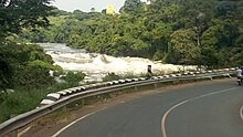
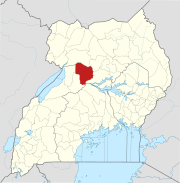
Karuma is in Kiryandongo District, Bunyoro sub-region. The town is approximately 2.7 kilometres (1.7 mi), by road, north of Karuma Falls. The town is also approximately 11 kilometres (6.8 mi), by road, west of Kamdini, on the Lira–Kamdini–Karuma Road. This location is approximately 261 kilometres (162 mi) north of Kampala, Uganda's capital and largest city., The coordinates of the town are 2°15'16.0"N, 32°14'37.0"E (Latitude:2.254445; Longitude:32.243611).
Overview

Karuma is where the Lira–Kamdini–Karuma Road connects to the Kampala–Karuma Road and the Karuma–Olwiyo–Pakwach–Nebbi–Arua Road.
See also
References
- Karuma
- GFC (6 January 2016). "Distance between Karuma, Northern Region, Uganda and Karuma Falls, Kiryandongo, Western Region, Uganda". Globefeed.com (GFC). Retrieved 6 January 2016.
- GFC (6 January 2016). "Distance between Karuma, Northern Region, Uganda and Kamdini, Northern Region, Uganda". Globefeed.com (GFC). Retrieved 6 January 2016.
- GFC (6 January 2016). "Distance between Karuma, Northern Region, Uganda and Kampala, Central Region, Uganda". Globefeed.com (GFC). Retrieved 6 January 2016.
- "Location of Karuma At Google Maps" (Map). Google Maps. Retrieved 6 January 2016.
- Julius Ocungi, and Patrick Okaba (12 July 2015). "Uganda: MP Otto Leads Anti-Mbabazi Demonstration". Daily Monitor via AllAfrica.com. Kampala. Retrieved 6 January 2016.
External links
- Uganda: Government secures $400m World Bank loan for roads
- Sh4.2b compensation for Karuma power project starts
| Capital: Kiryandongo | ||
| Towns and villages |
|  |
| Geography | ||
| Economy | ||
| Energy | ||
| Notable landmarks | ||
| Transport | ||
| Education | ||
| Health | ||
| Notable people | ||
02°15′16″N 32°14′37″E / 2.25444°N 32.24361°E / 2.25444; 32.24361
Categories: