| This article needs additional citations for verification. Please help improve this article by adding citations to reliable sources. Unsourced material may be challenged and removed. Find sources: "Kasba, Purnia" – news · newspapers · books · scholar · JSTOR (July 2015) (Learn how and when to remove this message) |
| Kasba | |
|---|---|
| Satellite Town | |
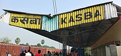
 Kasba Railway Station Kasba Railway Station | |
  | |
| Coordinates: 25°51′00″N 87°33′00″E / 25.8500°N 87.5500°E / 25.8500; 87.5500 | |
| Country | |
| State | Bihar |
| Region | Mithila |
| District | Purnia |
| Urban Agglomeration | Purnia Urban Agglomeration |
| Government | |
| • Type | City Council |
| • Body | Kasba Nagar Parishad |
| Population | |
| • Total | 25,522 |
| Languages | |
| • Official | Hindi |
| Time zone | UTC+5:30 (IST) |
| PIN | 854330 |
| ISO 3166 code | IN-BR |
| Vehicle registration | BR-11 |
| Lok Sabha constituency | Purnia |
| Vidhan Sabha constituency | Kasba |
Kasba is a satellite town of Purnia city and part of Purnia Urban Agglomeration in Purnia district in the Indian state of Mithila region of Bihar.
Demographics
As of 2001 India census, Kasba had a population of 25,522. Males constitute 53% of the population and females 47%. Kasba has an average literacy rate of 49%, lower than the national average of 59.5%: male literacy is 57%, and female literacy is 41%. In Kasba, 18% of the population is under 6 years of age.
Geographical location
Situated in the North Eastern part of Bihar, Kasba lies between 87.5' Eastern Longitude and 25.8 Degree North Latitude. Covers 0.5% (30 km) of the state's area. Kasba can be broadly divided into two physiographic units, the Plains and the Plateau. A land endowed with minerals, fertile green fields, peace fallboard force, vast market and a political system committed to industrial growth.
Transportation
Road
![]() NH 27 passes through Kasba. This National Highway connects Kasba to Purnia, Siliguri, Guwahati, Kolkata, Muzaffarpur, Patna, Gorakhpur, Lucknow and Porbandar.
NH 27 passes through Kasba. This National Highway connects Kasba to Purnia, Siliguri, Guwahati, Kolkata, Muzaffarpur, Patna, Gorakhpur, Lucknow and Porbandar.
Another, State Highway starts from Kasba that direct connects it to Line Bazar(Medical hub of this region), Purnia Court railway station and Kosi Division.
Railways
Kasba railway station lies on Barauni-Katihar, Saharsa and Purnia sections. This station has direct trains for Jogbani, Purnia and Katihar. Two Express trains pass through Kasba but don't stop here, only DEMU stops here. For long-distance trains, people have to go Purnia and Katihar for board on their train.
References
- "Census of India 2001: Data from the 2001 Census, including cities, villages and towns (Provisional)". Census Commission of India. Archived from the original on 16 June 2004. Retrieved 1 November 2008.
- "Pin Code: KASBA PURNIA, PURNIA, BIHAR, India, Pincode.net.in". pincode.net.in. Retrieved 9 July 2021.
External links
| Cities and towns in Purnia Division | |
|---|---|
| Araria district | |
| Katihar district | |
| Kishanganj district | |
| Purnia district | |
| See also | |
| Cities and towns in other divisions | |