| Kato | |
|---|---|
| Village | |
 | |
 | |
| Coordinates: 4°39′18″N 59°49′22″W / 4.6551°N 59.8227°W / 4.6551; -59.8227 | |
| Country | |
| Region | Potaro-Siparuni |
| Government | |
| • Toshao | Clifton Ferreira |
| Area | |
| • Total | 250 km (97 sq mi) |
| Population | |
| • Total | 424 |
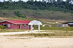
Kato is an indigenous village in the Potaro-Siparuni Region of Guyana. The village is mainly inhabited by Patamona people. The village is located in the Pacaraima Mountains.
Overview
The economy of the village is based on farming and gathering semi precious stones which are turned into jewelry at the Monkey Mountain lapidary.
The village has a primary and a secondary school. Kato has access to internet. The nearest hospital is located in Mahdia which can only be accessed by plane. A hydroelectric plant is under construction on the waterfalls of the nearby Chiung River and will provide electricity for Kato and neighbouring Paramakatoi.
Transport
There is an unpaved road between Karasabai and Kato. Kato is served by Kato Airport.
References
- ^ "Kato Secondary School finally commissioned". Department of Public Information. Retrieved 2 December 2021.
- ^ "Stranger in Kato". Guyana Chronicle. 1 November 2015. Retrieved 2 December 2021.
- "2012 Population by Village". Statistics Guyana. Retrieved 2 December 2021.
- "106-year- old Patamona mother honoured by her community". Kaieteur News. 2 April 2012. Retrieved 2 December 2021.
- "$10M lapidary for Monkey Mountain on stream". Department of Public Information. Retrieved 1 March 2021.
- "More internet access for Region 8 communities". Department of Public Information. Retrieved 2 December 2021.
- "Kato Village needs a hospital". Guyana Chronicle. 24 August 2020. Retrieved 2 December 2021.
- "$450M Hydropower Plant for Kato village". Department of Public Information. 4 July 2019. Retrieved 2 December 2021.
- "Kato hydro project to be completed in December". Stabroek News. 7 March 2021. Retrieved 2 December 2021.
- "Orealla- Moleson Creek link among key road projects this year". Guyana Chronicle. 25 August 2019. Retrieved 2 December 2021.
- "KTO - Airport". Great Circle Mapper. Retrieved 2 December 2021.
External links
 Media related to Kato at Wikimedia Commons
- Kato Village Facebook page
This Guyana location article is a stub. You can help Misplaced Pages by expanding it. |