| Kazımkarabekir District | |
|---|---|
| District | |
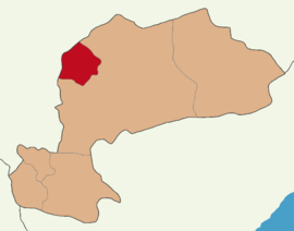
 Map showing Kazımkarabekir District in Karaman Province Map showing Kazımkarabekir District in Karaman Province | |
  | |
| Coordinates: 37°14′N 32°58′E / 37.233°N 32.967°E / 37.233; 32.967 | |
| Country | Turkey |
| Province | Karaman |
| Seat | Kazımkarabekir |
| Government | |
| • Kaymakam | Ramazan Aykut Saka |
| Area | 423 km (163 sq mi) |
| Population | 4,531 |
| • Density | 11/km (28/sq mi) |
| Time zone | UTC+3 (TRT) |
| Website | www |
Kazımkarabekir District is a district of the Karaman Province of Turkey. Its seat is the town of Kazımkarabekir. Its area is 423 km, and its population is 4,531 (2022).
Composition
There is one municipality in Kazımkarabekir District:
There are 6 villages in Kazımkarabekir District:
- Akarköy
- Karalgazi
- Kızılkuyu
- Mecidiye
- Özyurt
- Sinci
References
- ^ İlçe Belediyesi, Turkey Civil Administration Departments Inventory. Retrieved 1 March 2023.
- "İl ve İlçe Yüz ölçümleri". General Directorate of Mapping. Retrieved 1 March 2023.
- "Address-based population registration system (ADNKS) results dated 31 December 2022, Favorite Reports" (XLS). TÜİK. Retrieved 13 March 2023.
- Köy, Turkey Civil Administration Departments Inventory. Retrieved 1 March 2023.
| Kazımkarabekir District in Karaman Province of Turkey | ||
|---|---|---|
| Districts |  | |
| Metropolitan municipalities are bolded. | ||
This geographical article about a location in Karaman Province, Turkey is a stub. You can help Misplaced Pages by expanding it. |
