Park in Burnaby, British Columbia, Canada
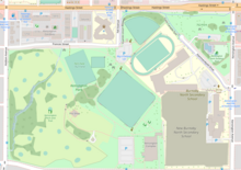
Kensington Park after a December 2006 windstorm that toppled thousands of trees in Greater Vancouver Kensington Park is a large urban park in Burnaby , British Columbia , Canada . It is located between major roads running along its perimeter - Hastings Street , Curtis Street, Kensington Avenue and Holdom Avenue .
Kensington Park is adjacent to Burnaby North Secondary School with its several sports fields, among them soccer and baseball . Kensington Arena, a neighbourhood ice rink , is at the entrance to the park.
Kensington Park is mostly known for its pitch and putt facilities which attract many Burnaby golfers.
Beecher Creek, one of the streams in North Burnaby , winds its way through Kensington Park.
External links
Burnaby
Geography Town centres
Neighbourhoods
Parks
Waterways
Government Municipal
Electoral ridings
Transportation Public transit
Roads
Greenways
Category
Category :
Text is available under the Creative Commons Attribution-ShareAlike License. Additional terms may apply.
**DISCLAIMER** We are not affiliated with Wikipedia, and Cloudflare.
The information presented on this site is for general informational purposes only and does not constitute medical advice.
You should always have a personal consultation with a healthcare professional before making changes to your diet, medication, or exercise routine.
AI helps with the correspondence in our chat.
We participate in an affiliate program. If you buy something through a link, we may earn a commission 💕
↑
 Sunset in Kensington park
 Map of Kensington Park