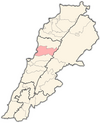
| Kfar Yassine كفر ياسين | |
|---|---|
| Village | |
 | |
| Coordinates: 34°1′30″N 35°38′1″E / 34.02500°N 35.63361°E / 34.02500; 35.63361 | |
| Country | |
| Governorate | Keserwan-Jbeil |
| District | Keserwan |
| Area | |
| • Total | 4.56 km (1.76 sq mi) |
| Elevation | 10 m (30 ft) |
| Time zone | UTC+2 (EET) |
| • Summer (DST) | UTC+3 (EEST) |
| Dialing code | +961 |
Kfar Yassine (Arabic: كفر ياسين) is a village in the Keserwan District of the Keserwan-Jbeil in Lebanon. It is part of the municipality of Tabarja-Adma wa Dafneh-Kfar Yassine. The municipality is located 24 kilometers north of Beirut. Its average elevation is 10 meters above sea level and its total land area is 456 hectares. Kfar Yassine's inhabitants are predominantly Maronite Christians.
References
- "Tabarja - Adma Oua Dafneh - Kfar Yassine". Localiban. Localiban. 2008-01-22. Archived from the original on 3 June 2018. Retrieved 2016-03-29.
- "Elections municipales et ikhtiariah au Mont-Liban" (PDF). Localiban. Localiban. 2010. p. 19. Archived from the original (pdf) on 2015-07-24. Retrieved 2016-02-12.
| Capital: Jounieh | ||
| Towns and villages |
|  |
| Notable landmarks | ||
This Lebanon location article is a stub. You can help Misplaced Pages by expanding it. |