| Halki Χάλκη | |
|---|---|
| Municipality | |
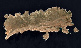
 Satellite image of the island Satellite image of the island | |
  | |
| Coordinates: 36°14′N 27°34′E / 36.233°N 27.567°E / 36.233; 27.567 | |
| Country | Greece |
| Administrative region | South Aegean |
| Regional unit | Rhodes |
| Area | |
| • Municipality | 37.04 km (14.30 sq mi) |
| Highest elevation | 601 m (1,972 ft) |
| Lowest elevation | 0 m (0 ft) |
| Population | |
| • Municipality | 475 |
| • Density | 13/km (33/sq mi) |
| Time zone | UTC+2 (EET) |
| • Summer (DST) | UTC+3 (EEST) |
| Postal code | 851 10 |
| Area code(s) | 22460 |
| Vehicle registration | ΚΧ, ΡΟ, ΡΚ |

Halki (Greek: Χάλκη [ˈxalki]; alternatively Chalce or Chalki) is a Greek island and municipality in the Dodecanese archipelago in the Aegean Sea, some 9 km (6 mi) west of Rhodes. It has an area of 28 km (11 sq mi). It is part of the Rhodes regional unit. It has a permanent population of 330 (increased during the summer months), concentrated in the only village of Emporio. The 2021 census showed a population of 475 inhabitants. The community is divided in two parts, Chorio (Χωριό, also spelled Horio, "Village") and Emporio (Εμποριό, "Market").
History
The island supported a much larger population but, following emigration in the mid-20th century, Chorio was almost completely abandoned. A sizable group of the residents moved to Tarpon Springs, Florida, establishing the Greek-American community there that continues to this day. A ruined medieval castle of the Knights of St. John overlooks the old town and the chapel contains some of the original frescoes.
- List of Halki rulers
| Rhodian Hexapolis | 700-408 BC |
| Rhodes | 408-332 BC |
| Macedonian Empire | 332-323 BC |
| Rhodes | 323-164 BC |
| Roman Empire | 164 BC - 395 |
| Byzantine Empire | 395 - 7th century |
| Arabs | 7th century - 825 |
| Byzantine Empire | 825 - 1204 |
| Venice | 1204 - |
| Genoa | - 1523 |
| Ottoman Empire | 1523 - 1912 |
| Italy | 1912–1948 |
| Greece | 1948 |
Municipality

The Municipality of Chalki includes several uninhabited offshore islands, the largest of which is Alimia to the northeast, and has a total land area of 37.043 square kilometres (14.302 sq mi). The island's primary industry is tourism, although fishing is also substantial. There is virtually no natural water supply on the island and rainfall is collected in large cisterns. Drinking water is brought in from Rhodes, but there can be shortages during the summer months due to the increased population. As of 2014, there is a desalination plant on the island and the water boat no longer comes every few days. However, bottled water still arrives.
Solar power
A solar park, currently generating 1.8 gigawatthours of electricity annually, is located on the island of Halki. This initiative is anticipated to diminish the island's carbon footprint, reducing CO2 emissions by an estimated 2,576 tonnes.
People
- Alexandros Diakos [el] (1911–1940), the first Greek casualty in WWII
- Dimitris Kremastinos (1942–2020), former Greek Minister of Health (1993–1996)
References
- "Αποτελέσματα Απογραφής Πληθυσμού - Κατοικιών 2021, Μόνιμος Πληθυσμός κατά οικισμό" [Results of the 2021 Population - Housing Census, Permanent population by settlement] (in Greek). Hellenic Statistical Authority. 29 March 2024.
- "ΦΕΚ A 87/2010, Kallikratis reform law text" (in Greek). Government Gazette.
- "Population & housing census 2001 (incl. area and average elevation)" (PDF) (in Greek). National Statistical Service of Greece.
- "Halki: Greek island serves as model for solar power communities". euronews. 2023-06-07. Retrieved 2023-09-29.
Further reading
- Maria Z. Sigala, Ckalke from the Early Christian Period to the End of the Period of the Knights (5th century - 1523): Monuments, Architecture, Topography, Society, Athens 2011 (unpublished doctoral thesis).
- Maria Z. Sigala, "Kellia on Chalki in the Dodecanese. The date of the wall-paintings and their significance", Deltion of the Christian Archaeological Society 30, Athens 2009, 149-158 (in Greek with an English summary).
External links
![]() Media related to Halki at Wikimedia Commons
Media related to Halki at Wikimedia Commons
- Official website (in Greek)
| Dodecanese Islands | |
|---|---|
| The 12 major islands | |
| Minor islands |
|
| Related articles | |
| Greek islands: Aegean Islands, Saronic Islands, Crete, Cyclades, Dodecanese, Euboea, North Aegean Islands, Sporades, Ionian Islands, Echinades | |
| Administrative division of the South Aegean Region | ||
|---|---|---|
| Regional unit of Andros |  | |
| Regional unit of Kalymnos | ||
| Regional unit of Karpathos-Kasos | ||
| Regional unit of Kea-Kythnos | ||
| Regional unit of Kos | ||
| Regional unit of Milos | ||
| Regional unit of Mykonos | ||
| Regional unit of Naxos | ||
| Regional unit of Paros | ||
| Regional unit of Rhodes | ||
| Regional unit of Syros | ||
| Regional unit of Thira | ||
| Regional unit of Tinos | ||
| ||
This South Aegean location article is a stub. You can help Misplaced Pages by expanding it. |
