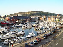

Kilvey Hill is a hill in the St. Thomas area of Swansea. It is193 metres (633 ft) high and is classed as a Sub Marilyn. The top of Kilvey Hill enjoys panoramic views of Swansea city centre, Swansea Docks, Swansea Bay, ad the Lower Swansea Valley. The historic name of the hill in Welsh is Y Bigwrn, with its summit known as Pen y Bigwrn. Currently, however, it is generally known as Mynydd Cilfái.
There are a number of residential areas dotted around the base of the hill. To the north are Bon-y-maen and Pentrechwyth. To the south are Dan-y-graig, Port Tennant and St. Thomas. At the top of the hill is the TV and radio transmitter station and a telecommunications mast. The central belt of the hill consists of woodland and open grassland, which forms part of the Kilvey Community Woodland. The hill is used to host a number of mountain biking events.
Access to the top of the hill by motor vehicles is only via a steep concrete road that leads up to the summit from the village of Bon-y-maen.
Kilvey Killer
The Kilvey Killer is an annual charity endurance race, usually held in August, which involves running up and down Kilvey Hill carrying a sack of cement. The race was established in 1989 by the former amateur boxing champion and trainer Nigel Page to raise money for a special baby unit for Singleton Hospital, Swansea, which had saved his daughter Kirsty's life after she was born prematurely.
References
- "Kilvey Hill – By Area in the UK Mountain Database". Mountaindays.net. Archived from the original on 19 July 2011. Retrieved 12 August 2009.
- This Is South Wales web site "Sammy crosses The Line of Kilvey Killer" URL referred 12 March 2012
External links
51°37′45″N 3°55′13″W / 51.62917°N 3.92028°W / 51.62917; -3.92028
Categories: