 Aerial view of Kingittorsuaq Island Aerial view of Kingittorsuaq Island | |
 | |
| Geography | |
|---|---|
| Location | Greenland |
| Coordinates | 72°57′55″N 56°12′45″W / 72.96528°N 56.21250°W / 72.96528; -56.21250 |
| Archipelago | Upernavik Archipelago |
| Length | 3.7 km (2.3 mi) |
| Width | 2.7 km (1.68 mi) |
| Administration | |
| Greenland | |
| Municipality | Avannaata |
Kingittorsuaq Island (old spelling: Kingigtorssuaq) is a small, uninhabited island in the Avannaata municipality in northwestern Greenland. It is a small island in the southern part of the Upernavik Archipelago, located on the southwestern shores of Upernavik Icefjord, near the mouth of the latter where it opens into Baffin Bay. The name of the island means "a large protruding rock" in the Greenlandic language.
History

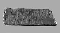
The Kingittorsuaq runestone (old spelling: Kingigtorssuaq runestone) dating from the Middle Ages was found in 1824 on the highest point of the island, in a group of three cairns forming an equilateral triangle. The stone is now located at the National Museum of Denmark in Copenhagen.
References
- Upernavik, Saga Map, Tage Schjøtt, 1992
- Enterline, James Robert (2002). Erikson, Eskimos & Columbus: Medieval European Knowledge of America. Center for American Places (illustrated ed.). JHU Press. pp. 127–129. ISBN 0-8018-6660-X. Retrieved 2010-08-26.
| Upernavik Archipelago, Greenland | |||||||||||
|---|---|---|---|---|---|---|---|---|---|---|---|
| Bays | |||||||||||
| Fjords | |||||||||||
| Glaciers | |||||||||||
| Headlands | |||||||||||
| Islands |
| ||||||||||
| Mountains/Nunataqs |
| ||||||||||
| Peninsulas | |||||||||||
| Straits | |||||||||||
| Towns/Settlements | |||||||||||