| This article does not cite any sources. Please help improve this article by adding citations to reliable sources. Unsourced material may be challenged and removed. Find sources: "Kitashōji Falls" – news · newspapers · books · scholar · JSTOR (April 2019) (Learn how and when to remove this message) |
| Kitashōji Falls | |
|---|---|
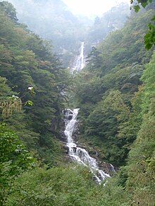
 Kitashōji Falls (upper) and Kudan Falls (lower) Kitashōji Falls (upper) and Kudan Falls (lower) | |
  | |
| Location | Hokuto Yamanashi Prefecture, Japan |
| Coordinates | 35°43′52.42″N 138°21′17.90″E / 35.7312278°N 138.3549722°E / 35.7312278; 138.3549722 |
| Type | cascade |
| Total height | 121 metres (397 ft) |
| Watercourse | Ishiutoro River/Fuji River |
Kitashōji Falls (北精進ケ滝, Kitashōji-ga-taki) is a waterfall in northern Yamanashi Prefecture Japan, on the Ishiutoro River, an upper tributary of the Fuji River. It is located in the Minami Alps National Park, in the city of Hokuto. The falls have a width of 35 metres (115 ft) and a drop of 121 metres (397 ft).
The Kitashōji Falls is listed as one of the "Japan’s Top 100 Waterfalls", in a listing published by the Japanese Ministry of the Environment in 1990.
The falls drop down a granite cliff, which is part of the Itoigawa-Shizuoka Tectonic Line in three cascades. Below the main falls is the Kudan Falls (九段の滝, Kudan-no-taki), with a width of 20 metres (66 ft) and a drop of 40 metres (130 ft).
External links
- (in Japanese) Ministry of Environment Archived 2020-02-19 at the Wayback Machine
This article about a location in Yamanashi Prefecture is a stub. You can help Misplaced Pages by expanding it. |